Back Coburg (bahin nga lungsod) CEB Coburg (Victoria) German Coburg, Victoria English کوبرگ، ویکتوریا Persian Coburg (Australie) French Coburg (Victoria) Dutch Coburg, Victoria Swedish کوبرگ، وکٹوریہ Urdu
| Coburg Melbourne, Victoria | |||||||||||||||
|---|---|---|---|---|---|---|---|---|---|---|---|---|---|---|---|
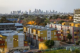
 Coburg looking towards the City of Melbourne 2020 | |||||||||||||||
 | |||||||||||||||
| Coordinates | 37°44′38″S 144°57′52″E / 37.7438°S 144.9645°E | ||||||||||||||
| Population | 26,574 (2021 census)[1] | ||||||||||||||
| • Density | 3,800/km2 (9,800/sq mi) | ||||||||||||||
| Postcode(s) | 3058 | ||||||||||||||
| Elevation | 63 m (207 ft) | ||||||||||||||
| Area | 7 km2 (2.7 sq mi) | ||||||||||||||
| Location | 8 km (5 mi) N of Melbourne | ||||||||||||||
| LGA(s) | |||||||||||||||
| State electorate(s) | |||||||||||||||
| Federal division(s) | |||||||||||||||
| |||||||||||||||
Coburg is a suburb of Melbourne, Victoria, Australia. It is about 8km north of the Melbourne central business district. In 2006 there were 22,772 people living in the suburb. It is a part of the City of Moreland local government area.
Before European settlement the Coburg area was home to the Indigenous Australian Wurundjeri people. The area was first surveyed in 1837-8 by Robert Hoddle. The area was first called Pentridge, after the town of Pentridge, Dorset, England.
- ↑ Australian Bureau of Statistics (28 June 2022). "Coburg (Suburbs and Localities)". 2021 Census QuickStats. Retrieved 2 July 2022.
