Back Kreta Afrikaans Kreta ALS ቀርጤስ Amharic Creta AN Creto ANG كريت Arabic ܩܪܛܐ ARC كريت ARY كريت ARZ Creta AST
Crete
Περιφέρεια Κρήτης | |
|---|---|
 Crete | |
 | |
| Coordinates: 35°13′N 24°55′E / 35.21°N 24.91°E | |
| Country | |
| Capital | Heraklion |
| Regional units | |
| Government | |
| • Regional governor | Stavros Arnaoutakis (PASOK) |
| Area | |
| • Total | 8,336 km2 (3,219 sq mi) |
| Highest elevation | 2,456 m (8,058 ft) |
| Population (2011) | |
| • Total | 621,340 |
| • Density | 75/km2 (190/sq mi) |
| ISO 3166 code | GR-M |
| Website | www |

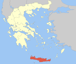
Crete is the largest of the Greek islands. It separates the Aegean Sea from the rest of the Mediterranean Sea.
Like the Fertile Crescent, Crete had rich soil, a warm climate, and plenty of water.[1] With less time spent fighting to live, the Cretans began to make complicated things. From the wild crocus flowers which covered their island, the Cretans collected saffron used in yellow dye, in food, and in medicine. From the Egyptians, they received rich cloth and jewels. From the Hittites, they learned how to use iron. From the wealthy Lydians, they learned to use money. From Phoneicia, the Cretans received the alphabet which is used today.
In various later centuries the island was ruled in turn by ancient Greeks, Romans, Arabs, Venetians, Turks, and modern Greeks.
- ↑ Hofflund, M.A., Ethel. History and Geography 603 The Civilizations of Greece and Rome. Rock Rapids: Alpha Omega Publications, Inc.