Back Groot Vlaktes Afrikaans السهول الكبرى Arabic Grandes Llanures AST Böyük Düzənliklər Azerbaijani Вялікія раўніны Byelorussian Големи равнини Bulgarian ग्रेट प्लेन्स Bihari গ্রেট প্লেইনস Bengali/Bangla Plaenennoù Bras Breton Velika nizija BS

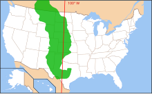
The Great Plains is a large space of level land or prairie in the middle and western parts of North America. It is a steppe or grassland.
The western boundary is the Rocky Mountains. In the east, the Great Plains grassland becomes the tallgrass of the Mississippi River basin. The prairie is (in whole or part) in eleven U.S. states, and in the southern parts of three Canadian provinces.
In the Great Plains, summers are hot and humid, but winters are cold. Bison used to number millions, and were the main food for people there. Now the area is mainly sown with cereal crops which feed cattle and people.