Back مطار إنفرنيس Arabic مطار انفرنيس ARZ Aeropuertu d'Inverness AST Inverness Dalcross Airport CEB Flughafen Inverness German Inverness Airport English Aeropuerto de Inverness Spanish فرودگاه اینورنس Persian Aéroport d'Inverness French Port-adhair Inbhir Nis Scots/Gaelic
Inverness Airport Port-adhair Inbhir Nis | |||||||||||||||
|---|---|---|---|---|---|---|---|---|---|---|---|---|---|---|---|
 | |||||||||||||||
| Summary | |||||||||||||||
| Airport type | Private | ||||||||||||||
| Owner/Operator | Highlands and Islands Airports Limited | ||||||||||||||
| Serves | Inverness | ||||||||||||||
| Location | Dalcross, Highland | ||||||||||||||
| Elevation AMSL | 31 ft / 9 m | ||||||||||||||
| Coordinates | 57°32′33″N 004°02′51″W / 57.54250°N 4.04750°W | ||||||||||||||
| Website | invernessairport.co.uk | ||||||||||||||
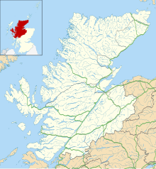
| Map | |||||||||||||||
| Runways | |||||||||||||||
| |||||||||||||||
| Statistics (2018) | |||||||||||||||
| |||||||||||||||
Inverness Airport [3] is an international airport at Dalcross, 7 nautical miles (~8 miles or 13 km) north east of the city of Inverness in the Scottish Highlands.
The airport is the main gateway for travellers to the Highlands and Islands. There are a wide range of scheduled services throughout the United Kingdom and Ireland; also there are limited charter and freight flights to continental Europe. 591,397 passengers passed through the airport in 2009.[2] It is owned by Highlands and Islands Airports Limited (HIAL) who own most of the regional airports in mainland Scotland and the outlying islands.
Like many of the airports in the Highlands and Islands, this airport was originally a RAF air base, and played a role in World War II. It was converted to civilian use in 1947.
- ↑ "Inverness - EGPE". EAD-IT.com. Archived from the original on 27 February 2012. Retrieved 16 December 2017.
- ↑ 2.0 2.1 "Aircraft and passenger traffic data from UK airports". UK Civil Aviation Authority. 11 March 2017. Retrieved 11 March 2017.
- ↑ Scottish Gaelic: Port-adhair Inbhir Nis (IATA: INV, ICAO: EGPE)
