Back الأراضي التي تحتلها إسرائيل Arabic ইজৰাইলৰ দখলকৃত অঞ্চলসমূহ Assamese İsrailin işğal etdiyi ərazilər Azerbaijani ইসরায়েল-দখলকৃত অঞ্চলসমূহ Bengali/Bangla Území okupovaná Izraelem Czech Israelisch besetzte Gebiete German Israeli-occupied territories English Israel-okupaciataj teritorioj Esperanto Territorios ocupados por Israel Spanish سرزمینهای اشغالشده توسط اسرائیل Persian

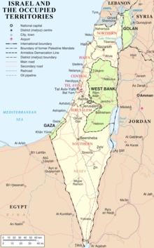
The Israeli-occupied territories are areas of other countries that are controlled by Israel. The current occupied territories include all of Palestine and Egypt (the West Bank/Judaeo–Samaria and Gaza, East Jerusalem, and the Sinai), Southern Lebanon and South Syria (Golan). They were established during the Six-Day War in 1967.
After the Israeli Independence war in 1948, or referred to by Palæstinians as “Nakba”, Jordan and Egypt dominated Judaeo-Samaria and Gaza, even East Jerusalem[1] and Syria, the Golan.[2] During the Fourth Geneva Convention (regarding the Protection of Civilian Persons in Time of War) the occupation was written down. It stated that the Israeli occupation of the State of Palæstina involves denying human rights, denying full citizenship, religious extremism, and lacking humanitarian protection. Israel controls the land and sea borders, trade and airspace.[3]
- ↑ Efrat, Elisha (2006). The West Bank and Gaza Strip: a geography of occupation and disengagement. London: Routledge. ISBN 978-0-415-38544-2.
- ↑ Davis, U. (1 January 1983). "The Golan Heights under Israeli occupation 1967-1981".
- ↑ Shafir, Gershon (2017). A half century of occupation: Israel, Palestine, and the world's most intractable conflict. Oakland (Calif.): University of California press. ISBN 978-0-520-29350-2.