Back مقاطعة ليفينوورث (كانساس) Arabic Leavenworth County, Kansas BAR Левънуърт (окръг, Канзас) Bulgarian লিভেনৱার্থ কাউন্টি, ক্যানসাস BPY Leavenworth Gông (Kansas) CDO Leavenworth County CEB Leavenworth County Czech Leavenworth County, Kansas Welsh Leavenworth County German Κομητεία Λίβενγουορθ (Κάνσας) Greek
Leavenworth County | |
|---|---|
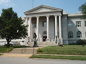
 Leavenworth County Courthouse in Leavenworth | |
 Location within the U.S. state of Kansas | |
 Kansas's location within the U.S. | |
| Coordinates: 39°16′07″N 95°07′32″W / 39.2686°N 95.1256°W | |
| Country | |
| State | |
| Founded | August 25, 1855 |
| Named for | Henry Leavenworth |
| Seat | Leavenworth |
| Largest city | Leavenworth |
| Area | |
| • Total | 469 sq mi (1,210 km2) |
| • Land | 463 sq mi (1,200 km2) |
| • Water | 6.1 sq mi (16 km2) 1.3% |
| Population | |
| • Total | 81,881 |
| • Density | 176.8/sq mi (68.3/km2) |
| Time zone | UTC−6 (Central) |
| • Summer (DST) | UTC−5 (CDT) |
| Congressional district | 2nd |
| Website | www |
Leavenworth County (county code LV) is a county in the U.S. state of Kansas. In 2020, 81,881 people lived there.[1] Its county seat is Leavenworth. Leavenworth is also the biggest city in Leavenworth County.[2]
- ↑ 1.0 1.1 "QuickFacts: Leavenworth County, Kansas". United States Census Bureau. Retrieved October 1, 2023.
- ↑ "Find a County". National Association of Counties. Retrieved 2011-06-07.