Back Leithfield CEB Leithfield English Leithfield (Nouvelle-Zélande) French Leithfield Maori Leithfield Polish
Leithfield | |
|---|---|
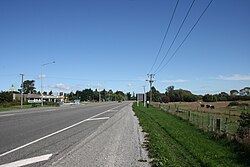
 State Highway 1 at the turn off to Leithfield Beach | |
 | |
| Coordinates: 43°12′S 172°44′E / 43.200°S 172.733°E | |
| Country | New Zealand |
| Region | Canterbury |
| Territorial authority | Hurunui District |
| Ward | South Ward |
| Electorates | |
| Government | |
| • Territorial Authority | Hurunui District Council |
| • Regional council | Environment Canterbury |
| • Mayor of Hurunui | Marie Black |
| • Kaikoura MP | Stuart Smith |
| • Te Tai Tonga MP | Tākuta Ferris |
| Area | |
| • Total | 1.58 km2 (0.61 sq mi) |
| Population (June 2023)[2] | |
| • Total | 1,040 |
| • Density | 660/km2 (1,700/sq mi) |
Leithfield is a small town in the Hurunui District, New Zealand. It is situated 5 kilometers south of Amberley and 42 kilometers north of Christchurch on State Highway 1. It has a primary school located in the town and lies south of the Kowai River.
- ↑ Cite error: The named reference
Areawas used but no text was provided for refs named (see the help page). - ↑ "Subnational population estimates (RC, SA2), by age and sex, at 30 June 1996-2023 (2023 boundaries)". Statistics New Zealand. Retrieved 25 October 2023. (regional councils); "Subnational population estimates (TA, SA2), by age and sex, at 30 June 1996-2023 (2023 boundaries)". Statistics New Zealand. Retrieved 25 October 2023. (territorial authorities); "Subnational population estimates (urban rural), by age and sex, at 30 June 1996-2023 (2023 boundaries)". Statistics New Zealand. Retrieved 25 October 2023. (urban areas)