Back Los Angeles-rivier Afrikaans نهر لوس أنجلوس Arabic نهر لوس انجلوس ARZ Los Angeles River CEB Los Angeles (řeka) Czech Los Angeles River German Royê Los Angelesi DIQ Los Angeles River English Río Los Ángeles Spanish Los Angeles (fleuve) French
| Los Angeles River Spanish: Río de Los Ángeles | |
|---|---|
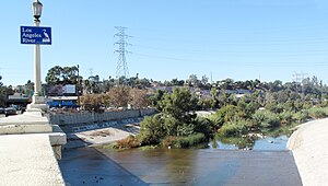
 L.A. River from Fletcher Drive Bridge | |
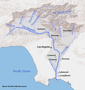
 Map of the Los Angeles River watershed | |
| Location | |
| Country | United States |
| State | California |
| Cities | Burbank, Glendale, Los Angeles, Downey, Compton, Long Beach |
| Physical characteristics | |
| Source | Confluence of Bell Creek and Arroyo Calabasas |
| - location | Canoga Park, San Fernando Valley |
| - coordinates | 34°11′43″N 118°36′08″W / 34.19528°N 118.60222°W[1] |
| - elevation | 794 ft (242 m) |
| Mouth | Pacific Ocean |
| - location | Los Angeles Harbor, Long Beach |
| - coordinates | 33°45′23″N 118°11′20″W / 33.75639°N 118.18889°W[1] |
| - elevation | 0 ft (0 m) |
| Length | 47.9 mi (77.1 km)[2] |
| Basin size | 827 sq mi (2,140 km2)[3] |
| Discharge | |
| - location | Long Beach[3] |
| - average | 226 cu ft/s (6.4 m3/s)[3] |
| - minimum | 2 cu ft/s (0.057 m3/s) |
| - maximum | 129,000 cu ft/s (3,700 m3/s) |
| Basin features | |
| Tributaries | |
| - left | Bell Creek, Browns Canyon Wash, Aliso Creek, Tujunga Wash, Verdugo Wash, Arroyo Seco, Rio Hondo |
| - right | Arroyo Calabasas, Compton Creek |
The Los Angeles River (also called: El Rio De Nuestra Senora La Reina De Los Angeles De Porciuncula or Porciuncula River;[4] Spanish: River of the Angels; informally LA River) is a river flowing through Los Angeles County, California, in the United States. About 51 miles (82 km) long, it flows from Canoga Park south and west to its end at the Long Beach Harbor, in San Pedro Bay, part of the Pacific Ocean. The basin is rimmed by the San Gabriel Mountains, Santa Monica Mountains and Santa Susana Mountains, as well as several smaller mountain ranges. Much of the water that flows in the Los Angeles River flows in from tributaries that come from the mountains.[5]
The river was once free-flowing, winding across a floodplain that occupied much of the Los Angeles Basin. With its frequent floods, it often changed course, causing erosion and depositing silt in other places. When the city of Los Angeles had its first settlers around the 1850s, the river was its main water source. With the opening of the Los Angeles Aqueduct in 1913,[6] the Los Angeles River was no longer needed as a water source. Today, the Los Angeles River runs in a fixed course through a concrete channel for nearly its whole length. It is heavily polluted. The primary source of water during summer and fall is the Donald C. Tillman Water Reclamation Plant in Van Nuys. Plans for restoration of the river are being discussed.[7]
- ↑ 1.0 1.1 "Los Angeles River". Geographic Names Information System. United States Geological Survey. 1981-01-19. Retrieved 2011-05-16.
- ↑ U.S. Geological Survey. National Hydrography Dataset high-resolution flowline data. The National Map Archived 2012-03-29 at the Wayback Machine, accessed 2011-05-07
- ↑ 3.0 3.1 3.2 "USGS Gage #11103000 on the Los Angeles River at Long Beach, CA". National Water Information System. U.S. Geological Survey. 1929–1992. Archived from the original on 2015-12-08. Retrieved 2011-05-16.
- ↑ "USGS GNIS Detail: Los Angeles River".
- ↑ The Los Angeles River: Its Life, Death, and Possible Rebirth. Blake Gumprecht. Baltimore and London: Johns Hopkins University Press, 1999. ISBN 0-8018-6047-4.
- ↑ "A Hundred or a Thousand Fold More Important". Los Angeles Department of Water and Power. Archived from the original on 2009-02-23. Retrieved 2009-02-07.
- ↑ "Views on the State and Beyond- The Los Angeles River: Restoration, (Re)Invention? The Politics of Nature in L.A." Archived from the original on 2010-07-10. Retrieved 2009-04-06.