Back Luxemburg (stad) Afrikaans Luxemburg (Stadt) ALS ሉክሰምበርግ (ከተማ) Amharic Luxemburgo (ciudat) AN لوكسمبورغ (مدينة) Arabic لوكسمبورݣ (مدينة) ARY مدينه لوكسمبورج ARZ Luxemburgu (ciudá) AST Люксембург (шагьар) AV Luxemburg AVK
Luxembourg
Luxembourg / Lëtzebuerg / Luxemburg | |
|---|---|
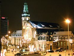
 The main railway station in Luxembourg | |
Map showing, in orange, Luxembourg | |
| Coordinates: 49°36′36″N 6°07′40″E / 49.61000°N 6.12778°E | |
| Country | Luxembourg |
| District | Luxembourg |
| Canton | Luxembourg |
| Commune | Luxembourg |
| Government | |
| • Mayor | Lydie Polfer (DP) |
| Area | |
| • Total | 51.7 km2 (20.0 sq mi) |
| Highest elevation | 408 m (1,339 ft) |
| Lowest elevation | 232 m (761 ft) |
| Population (2016)[1] | |
| • Total | 115,227 |
| • Density | 2,200/km2 (5,800/sq mi) |
| Time zone | UTC+1 (CET) |
| • Summer (DST) | UTC+2 (CEST) |
| LAU2 | LU00011001 |
| Website | Official website |
The city of Luxembourg (Luxembourgish: Lëtzebuerg, French: Luxembourg, German: Luxemburg), also known as Luxembourg City (Luxembourgish: Stad Lëtzebuerg, French: Ville de Luxembourg, German: Stadt Luxemburg), is a commune with city status, and the capital of the Grand Duchy of Luxembourg.
The city is at the confluence of the Alzette and Pétrusse rivers in southern Luxembourg. In the city is found the Luxembourg Castle, built by the Franks in the Early Middle Ages, around which a settlement developed.
- ↑ "Population by canton and municipality 1821 - 2016". Statistics Portal - Grand Duchy of Luxembourg. Archived from the original on 19 June 2021. Retrieved 6 June 2016.
