Back مقاطعة شانون (داكوتا الجنوبية) Arabic Oglala Lakota County, South Dakota BAR Оглала Лакота (окръг, Южна Дакота) Bulgarian শানন কাউন্টি, সাউথ ডাকোটা BPY Oglala Lakota Gông (South Dakota) CDO Оглала-Лакота (гуо, Къилба Дакота) CE Oglala Lakota County (kondado sa Tinipong Bansa, South Dakota) CEB Oglala Lakota County German Oglala Lakota County, South Dakota English Condado de Oglala Lakota Spanish
Oglala Lakota County | |
|---|---|
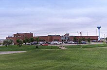
 Indian Health Service Hospital in Pine Ridge on the Pine Ridge Indian Reservation, November 2011 | |
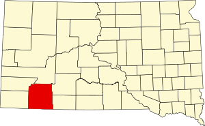
 Location within the U.S. state of South Dakota | |
 South Dakota's location within the U.S. | |
| Coordinates: 43°20′N 102°33′W / 43.33°N 102.55°W | |
| Country | |
| State | |
| Founded | 1875 |
| Named for | Oglala Lakota people |
| Seat | None (de jure) Hot Springs (de facto)[1] |
| Largest community | Pine Ridge |
| Area | |
| • Total | 2,097 sq mi (5,430 km2) |
| • Land | 2,094 sq mi (5,420 km2) |
| • Water | 2.8 sq mi (7 km2) 0.1% |
| Population (2020) | |
| • Total | 13,672 |
| • Density | 6.5/sq mi (2.5/km2) |
| Time zone | UTC−7 (Mountain) |
| • Summer (DST) | UTC−6 (MDT) |
| Congressional district | At-large |
| Website | oglalalakota |
| Hot Springs in neighboring Fall River County serves as administrative center for county[1] | |
Oglala Lakota County, known as Shannon County until May 2015, is a county located in the U.S. state of South Dakota. 13,672 people lived there at the 2020 census.[2] Oglala Lakota County does not have its own county seat. Instead, Hot Springs in neighboring Fall River County serves as its administrative center.[3] The county was created as a part of the Dakota Territory in 1875.[4][5] Its largest community is Pine Ridge.
- ↑ 1.0 1.1 Cite error: The named reference
defactowas used but no text was provided for refs named (see the help page). - ↑ "QuickFacts: Oglala Lakota County, South Dakota". United States Census Bureau. Retrieved January 20, 2024.
- ↑ National Association of Counties. "NACo County Explorer". Retrieved January 20, 2024.
- ↑ "Dakota Territory, South Dakota, and North Dakota: Individual County Chronologies". Dakota Territory Atlas of Historical County Boundaries. The Newberry Library. 2006. Archived from the original on April 2, 2018. Retrieved March 30, 2015.
- ↑ "South Dakota Legislative Manual" (PDF). South Dakota Secretary of State. 2005. p. 597. Archived from the original (PDF) on March 29, 2015. Retrieved March 30, 2015.