Back Palmadæl, Californie ANG بالمديل Arabic بالمديل ARZ Palmdeyl Azerbaijani پالمدئیل، کالیفورنیا AZB Палмдэйл Byelorussian Палмдейл Bulgarian Palmdale Catalan Палмдейл (Калифорни) CE Palmdale (lungsod sa Tinipong Bansa, California) CEB
Palmdale, California | |
|---|---|
 Palmdale, looking southeast toward the Antelope Valley Freeway and the San Gabriel Mountains | |
| Motto: "A Place to Call Home" | |
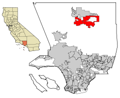
 Location of Palmdale in Los Angeles County, California | |
| Coordinates: 34°34′52″N 118°6′2″W / 34.58111°N 118.10056°W | |
| Country | United States |
| State | California |
| County | Los Angeles |
| Established | 1886 |
| Incorporated | August 24, 1962[1] |
| Area | |
| • City | 106.32 sq mi (275.37 km2) |
| • Land | 106.08 sq mi (274.74 km2) |
| • Water | 0.24 sq mi (0.63 km2) 0.24% |
| Elevation | 2,657 ft (810 m) |
| Population | |
| • City | 169,450 |
| • Rank | 6th in Los Angeles County 32nd in California |
| • Density | 1,600/sq mi (620/km2) |
| • Urban | 359,559 (US: 115th)[4] |
| • Urban density | 4,240.9/sq mi (1,637.4/km2) |
| Demonym | Palmdalite |
| Time zone | UTC−8 (Pacific Time Zone) |
| • Summer (DST) | UTC−7 (PDT) |
| ZIP Codes[6] | 93550–93552, 93590–93591, 93599 |
| Area code | 661 |
| FIPS code | 06-55156 |
| GNIS feature IDs | 1652769, 2411359 |
| Website | www |
Palmdale is the largest city in the desert area of California. It is a suburb of Los Angeles. It has a population of 169,450 and is the 6th largest city in Los Angeles County.
Even though Palmdale is in Los Angeles County, it is not connected to the larger Los Angeles population area. It is separated from it by a mountain range called the San Gabriel Mountains that are over 40 miles wide and almost 2 miles high overall. It is in Antelope Valley.
Palmdale is the home of several airplanes used by NASA and the Air Force, giving it the nickname of "the aerospace capital of America."
Palmdale Airport does not have any passenger air service.
The city's demographics is primarily Mexican and white. The most common ancestries are German, English, Irish, Italian and French. Spanish and Tagalog are the most common spoken foreign languages.[7]
- ↑ "California Cities by Incorporation Date". California Association of Local Agency Formation Commissions. Archived from the original (Word) on November 3, 2014. Retrieved August 25, 2014.
- ↑ "2019 U.S. Gazetteer Files". United States Census Bureau. Retrieved July 1, 2020.
- ↑ "Palmdale". Geographic Names Information System. United States Geological Survey. Retrieved October 13, 2014.
- ↑ United States Census Bureau (December 29, 2022). "2020 Census Qualifying Urban Areas and Final Criteria Clarifications". Federal Register.
- ↑ "Palmdale (city) QuickFacts". United States Census Bureau. Retrieved February 12, 2022.
- ↑ "ZIP Code(tm) Lookup". United States Postal Service. Retrieved November 30, 2014.
- ↑ [1]


