Back Pangea Afrikaans بانجيا Arabic Panxea AST Pangeya Azerbaijani Пангея Bashkir Pangea BAN Пангея Byelorussian Пангея BE-X-OLD Пангея Bulgarian প্যানজিয়া Bengali/Bangla


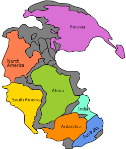
Pangaea[2] was the global supercontinent which formed in the Palaeozoic era. The process started about 450 million years ago (mya) and was complete by 210 mya. So, apart from some volcanic islands (not proven, but very likely), all the land areas were collected together in one big supercontinent.
Pangaea was the latest of a series of global supercontinents. They formed at various times since plate tectonics began on Earth.[3] Panthalassa was the name of the huge global ocean which surrounded Pangaea.
- ↑ Reconstruction based on Matte 2001; Stampfli et al 2002; Torsvik et al 1996 and Ziegler 1990
- ↑ meaning entire Earth in Ancient Greek
- ↑ "(PDF) Earth as an evolving planetary system". ResearchGate. Retrieved 2021-08-13.