Back مقاطعة ساغداوك (مين) Arabic ساقاداهوک بؤلگهسی، مئین AZB Sagadahoc County, Maine BAR Сагадахок (акруга) Byelorussian Сагадахок (окръг, Мейн) Bulgarian সগাডাহোক কাউন্টি, মেইন BPY Sagadahoc Gông (Maine) CDO Сагадахок (гуо, Мэн) CE Sagadahoc County CEB Sagadahoc County, Maine Welsh
Sagadahoc County | |
|---|---|
 Doubling Point Light and Bath Iron Works | |
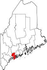
 Location within the U.S. state of Maine | |
 Maine's location within the U.S. | |
| Coordinates: 43°56′58″N 69°51′26″W / 43.949341°N 69.8573°W | |
| Country | |
| State | |
| Founded | February 14, 1854 |
| Named for | Abenaki word meaning "mouth of the big river;"[1] a former name for the Kennebec River |
| Seat | Bath |
| Largest city | Bath |
| Area | |
| • Total | 370 sq mi (1,000 km2) |
| • Land | 254 sq mi (660 km2) |
| • Water | 116 sq mi (300 km2) 31% |
| Population | |
| • Total | 36,699 |
| • Density | 99/sq mi (38/km2) |
| Time zone | UTC−5 (Eastern) |
| • Summer (DST) | UTC−4 (EDT) |
| Website | www |
Sagadahoc County (/ˈsæɡədəˌhɒk/ SAG-ə-də-hok) is a county in the state of Maine, in the United States. As of the 2020 census, the county's population was 36,699.[2] The county seat is Bath.[3]
- ↑ "Sagadahoc County".
- ↑ 2.0 2.1 "QuickFacts: Sagadahoc County, Maine". United States Census Bureau. Retrieved August 15, 2023.
- ↑ "Find a County". National Association of Counties. Retrieved 2011-06-07.