Back سابولبا Arabic سابولبا ARZ Sapalpa (Oklahoma) Azerbaijani سپالپا، اوکلاهوما AZB Sapulpa Catalan Сапалпа (Оклахома) CE Sapulpa CEB Sapulpa DAG Sapulpa German Sapulpa, Oklahoma English
Sapulpa, Oklahoma | |
|---|---|
 Creek County Courthouse, 2014 | |
| Motto: "Oklahoma's Most Connected City" | |
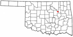
 Location of Sapulpa, Oklahoma | |
| Coordinates: 36°0′43″N 96°05′49″W / 36.01194°N 96.09694°W | |
| Country | United States |
| State | Oklahoma |
| Counties | Creek, Tulsa[1] |
| Area | |
| • Total | 24.27 sq mi (62.87 km2) |
| • Land | 23.50 sq mi (60.86 km2) |
| • Water | 0.78 sq mi (2.01 km2) |
| Elevation | 719 ft (219 m) |
| Population (2020) | |
| • Total | 21,929 |
| • Density | 933.19/sq mi (360.31/km2) |
| Demonym | Sapulpan |
| Time zone | UTC-6 (Central (CST)) |
| • Summer (DST) | UTC-5 (CDT) |
| ZIP codes | 74066-74067 |
| Area code(s) | 539/918 |
| FIPS code | 40-65400[4] |
| GNIS feature ID | 2411831[3] |
| Website | www |
Sapulpa is a city of the Creek and Tulsa counties in the U.S. state of Oklahoma. Around 21,929 people were living in Sapulpa as of 2020.[5] It is the county seat of Creek County. Sapulpa has an area of 24.2 square miles.
- ↑ "Zoning Index" (PDF). Archived from the original (PDF) on January 17, 2009.
- ↑ "ArcGIS REST Services Directory". United States Census Bureau. Retrieved September 20, 2022.
- ↑ 3.0 3.1 U.S. Geological Survey Geographic Names Information System: Sapulpa, Oklahoma
- ↑ "American FactFinder". United States Census Bureau. Archived from the original on 2020-02-12. Retrieved 2008-01-31.
- ↑ "DP1: PROFILE OF GENERAL POPULATION AND HOUSING CHARACTERISTICS". United States Census Bureau. Retrieved January 29, 2024.
