Back Sindh ACE السند (إقليم) Arabic Sindh AST Sind əyaləti Azerbaijani سیند ایالتی AZB Сінд Byelorussian Сынд BE-X-OLD Синд Bulgarian सिंध Bihari সিন্ধু প্রদেশ Bengali/Bangla
Sindh
سنڌ سندھ | |
|---|---|
 Ranikot Fort "(Great Wall of Pakistan)". | |
|
| |
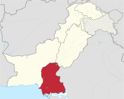
 Location of Sindh in Pakistan | |
 Map of Sindh, Pakistan | |
| Coordinates: 24°52′12″N 67°33′00″E / 24.87000°N 67.55000°E | |
| Country | Pakistan |
| Established | 1 July 1970 |
| Capital | Karachi |
| Largest city | Karachi |
| Government | |
| • Type | Province |
| • Body | Provincial Assembly |
| • High Court | Sindh High Court |
| Area | |
| • Total | 140,914 km2 (54,407 sq mi) |
| Population (2012 census preliminary)[1] | |
| • Total | 55,245,497 |
| • Density | 390/km2 (1,000/sq mi) |
| Time zone | UTC+5 (PKT) |
| Main Language(s) | Other: Punjabi, Pashto, Balochi, Saraiki[2][3][4] |
| Assembly seats | 168[5] |
| Districts | 27 |
| Towns | 119 |
| Union Councils | 1108[6] |
| Website | sindh.gov.pk |
Sindh (Sindhi: سنڌ) (Urdu: صوبہ سندھ) is a province in Pakistan. The provincial capital of Sindh is Karachi. Sindh has a population of 47.9 million people and an area of 54,407 mi² or (140,914 km²). The provincial region of Sindh is larger than Greece but smaller than Tajikistan,
- ↑ "Sind - type and level of administrative division". World Gazetteer. Archived from the original on 2012-12-08. Retrieved 2009-08-19.
- ↑ "Percentage Distribution of Households by Language Usually Spoken and Region/Province, 1998 Census" (PDF). Pakistan Statistical Year Book 2008. Federal Bureau of Statistics - Government of Pakistan. Archived from the original (PDF) on 18 November 2008. Retrieved 15 December 2009.
- ↑ "Sindh (province, Pakistan)" at Britannica Online Encyclopedia
- ↑ "About Sindh Archived 2010-06-20 at the Wayback Machine" at SindhToday.net
- ↑ "Provincial Assembly Seats". Archived from the original on 2014-12-14. Retrieved 2012-04-06.
- ↑ "Government of Sindh". Archived from the original on 2019-06-16. Retrieved 2012-04-06.

