Back Westervoort Afrikaans فيسترفورت Arabic Westervoort Catalan Gemeente Westervoort CEB Westervoort German Westervoort English Westervoort Esperanto Westervoort Spanish Westervoort Basque وسترفورت Persian
Westervoort | |
|---|---|
Municipality, town | |
 Street through Westervoort | |
 Location | |
 Map | |
| Coordinates: 51°58′N 5°58′E / 51.967°N 5.967°E | |
| Country | |
| Province | |
| Region | IJsselvallei, Liemers |
| Government | |
| • Body | Municipal council |
| • Mayor | Arend van Hout (VVD) |
| Area | |
| • Total | 7.84 km2 (3.03 sq mi) |
| • Land | 7.03 km2 (2.71 sq mi) |
| • Water | 0.81 km2 (0.31 sq mi) |
| Elevation | 11 m (36 ft) |
| Population (2019)[4] | |
| • Total | 14,944 |
| • Density | 2,126/km2 (5,510/sq mi) |
| Time zone | UTC+1 (CET) |
| • Summer (DST) | UTC+2 (CEST) |
| Postcode | 6931–6932 |
| Area code | 026 |
| Website | www |
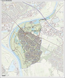
Westervoort is a municipality and town in the province of Gelderland, the Netherlands. About 15,000 people were living there in 2021.
It lies both in the IJsselvallei and Liemers regions, at the meeting point of the Rhine and IJssel rivers.
- ↑ "Samenstelling college van B&W". Gemeente Westervoort (in Dutch). Retrieved 14 February 2022.
- ↑ "Kerncijfers wijken en buurten 2020" [Key figures for neighbourhoods 2020]. StatLine (in Dutch). CBS. 24 July 2020. Retrieved 19 September 2020.
- ↑ "Postcodetool". Actueel Hoogtebestand Nederland (in Dutch). Archived from the original on 27 July 2014. Retrieved 14 February 2022.
- ↑ "Bevolkingsontwikkeling; regio per maand" [Population growth; regions per month]. CBS Statline (in Dutch). CBS. 1 January 2019. Retrieved 1 January 2019.

