Back Zeeland Afrikaans Zelanda AN زيلند (مقاطعة هولندية) Arabic زيلاند ARZ Zeeland BAN Зеландыя (правінцыя) Byelorussian Зэляндыя BE-X-OLD Зеландия Bulgarian জিল্যান্ড Bengali/Bangla Zeeland Breton
Zeeland
Zeeland / Zeêland | |
|---|---|
Province | |
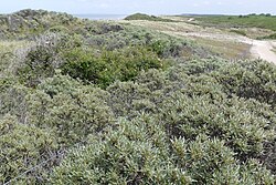
 Duinen van Domburg (municipality of Veere) | |
 Location | |
 Map | |
| Coordinates: 51°34′N 3°45′E / 51.567°N 3.750°E | |
| Country | Netherlands |
| Established | 1815 |
| Seat | Middelburg |
| Area | |
| • Total | 2,933 km2 (1,132 sq mi) |
| • Land | 1,780 km2 (690 sq mi) |
| • Water | 1,154 km2 (446 sq mi) |
| Highest elevation | 52 m (171 ft) |
| Lowest elevation | −2 m (−7 ft) |
| Population (2023) | |
| • Total | 391,000 |
| • Density | 220/km2 (600/sq mi) |
| Website | www |
Zeeland (also called Zealand) is a province in Netherlands. It is on the south-western part of the country. About 391,000 people are living in Zeeland (2023).

