Back ثوران كراكاتوا سنة 1883 Arabic Krakatau vulkanının püskürməsi (1883) Azerbaijani Вывяржэнне Кракатаў 1883 года Byelorussian ১৮৮৩ ক্রাকাতোয়া অগ্ন্যুৎপাত Bengali/Bangla Erupció del Krakatau de 1883 Catalan Έκρηξη του Κρακατόα το 1883 Greek Erupción del Krakatoa de 1883 Spanish فوران ۱۸۸۳ آتشفشان کراکاتوآ Persian Krakataun tulivuorenpurkaus 1883 Finnish Éruption du Krakatoa en 1883 French
| 1883 eruption of Krakatoa | |
|---|---|
 Photograph during the eruption in 1883 | |
| Volcano | Krakatoa |
| Start date | 20 May 1883[1] |
| End date | 21 October 1883[1] |
| Type | Plinian eruption[2] |
| Location | Krakatoa archipelago, Sunda Strait, Dutch East Indies (now Indonesia) 6°06′07″S 105°25′23″E / 6.102°S 105.423°E |
| VEI | 6[1] |
| Impact | Over 70% of the island of Krakatoa destroyed and collapsed into a caldera; 20 million tons of sulphur released; volcanic winter causes five-year average world temperature drop of 1.2 °C (2.2 °F)[citation needed] |
| Deaths | 36,417–120,000 |
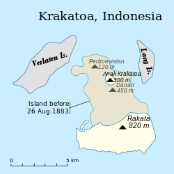
 The change in geography after the eruption | |

The 1883 eruption of Krakatoa (Indonesian: Letusan Krakatau 1883) in the Sunda Strait occurred from 20 May until 21 October 1883, peaking in the late morning of 27 August when over 70% of the island of Krakatoa and its surrounding archipelago were destroyed as it collapsed into a caldera.
The eruption was one of the deadliest and most destructive volcanic events in recorded history. The explosion was heard 3,110 kilometres (1,930 mi) away in Perth, Western Australia, and Rodrigues near Mauritius, 4,800 kilometres (3,000 mi) away.[3] The acoustic pressure wave circled the globe more than three times.[4]: 63 At least 36,417 deaths are attributed to the eruption and the tsunamis it created.
Significant additional effects were felt worldwide in the days and weeks after the volcano's eruption. Additional seismic activity was reported until February 1884, but any reports after October 1883 were dismissed by Rogier Verbeek's subsequent investigation into the eruption.
- ^ a b c "Krakatau". Global Volcanism Program. Smithsonian Institution. Retrieved 3 May 2021.
- ^ Self, Stephen (1992). "Krakatau revisited: The course of events and interpretation of the 1883 eruption". GeoJournal. 28 (2). Springer Science+Business Media: 109. Bibcode:1992GeoJo..28..109S. doi:10.1007/BF00177223. S2CID 189890473. Retrieved 20 May 2022.
- ^ Chisholm, Hugh, ed. (1911). . Encyclopædia Britannica. Vol. 15 (11th ed.). Cambridge University Press. p. 923.
- ^ Symons, G.J. (ed) The Eruption of Krakatoa and Subsequent Phenomena (Report of the Krakatoa Committee of the Royal Society). London, 1888. 1888 – via Internet Archive.