Back الچيرز، نيو اورلينز ARZ آلجیرز، نیو اورلینز AZB Algiers (New Orleans) German آلجایرز، نیواورلئان Persian Algiers (New Orleans) Italian
Algiers
15th Ward | |
|---|---|
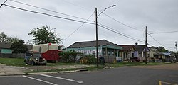
 Shotgun houses in Old Algiers | |
 Boundaries of the 15th Ward | |
| Coordinates: 29°55′30″N 90°00′50″W / 29.92500°N 90.01389°W | |
| Country | United States |
| State | Louisiana |
| City | New Orleans |
| Police District | District 4, Algiers |
| Area | |
• Total | 0.62 sq mi (1.6 km2) |
| • Land | 0.62 sq mi (1.6 km2) |
| • Water | 0.00 sq mi (0.0 km2) |
| Population (2010) | |
• Total | 25,995 |
| • Density | 42,000/sq mi (16,000/km2) |
| Demonyms | Algierene, or Algerine |
| Time zone | UTC-6 (CST) |
| • Summer (DST) | UTC-5 (CDT) |
| Area code | 504 |
Algiers (/ælˈdʒɪərz/) is a historic neighborhood of New Orleans and is the only Orleans Parish community located on the West Bank of the Mississippi River. Algiers is known as the 15th Ward, one of the 17 Wards of New Orleans.[1] It was once home to many jazz musicians[2][3] and is also the second oldest neighborhood in the city.[4]
- ^ "New Orleans Business Alliance - Living in New Orleans Neighborhoods". Archived from the original on February 16, 2016. Retrieved February 8, 2016.
- ^ "Interview of musician Tom Albert" (PDF). Music Rising at Tulane University. September 25, 1959. Retrieved July 30, 2018.
- ^ "Hogan Jazz Archive Photography Collection at Tulane University" (PDF). Hogan Jazz Archive at Tulane University. 1927. Retrieved July 30, 2018.
- ^ Campanella, Richard (August 8, 2017). "How Algiers grudgingly became part of New Orleans". Nola.com. Retrieved June 24, 2019.