Back أرجيل وبوت Arabic Argyll y Bute AST Аргайл і Б’ют Byelorussian Аргайл анд Бют Bulgarian Argyll ha Bute Breton Argyll and Bute Catalan Аргайл а, Бьют а CE Argyll and Bute CEB Argyll a Bute Czech Argyll a Bute Welsh
Argyll and Bute
| |
|---|---|
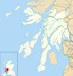
 Argyll and Bute shown within Scotland | |
| Coordinates: 56°06′N 5°30′W / 56.1°N 5.5°W | |
| Sovereign state | United Kingdom |
| Country | Scotland |
| Lieutenancy area |
|
| Unitary authority | 1 April 1996 |
| Administrative HQ | Kilmory Castle |
| Government | |
| • Type | Council |
| • Body | Argyll and Bute Council |
| • Control | No overall control |
| • MPs | Brendan O'Hara (SNP) |
| • MSPs | 2 MSPs |
| Area | |
• Total | 2,667 sq mi (6,907 km2) |
| • Rank | 2nd |
| Population (2022)[2] | |
• Total | 87,920 |
| • Rank | 27th |
| • Density | 30/sq mi (13/km2) |
| Time zone | UTC+0 (GMT) |
| • Summer (DST) | UTC+1 (BST) |
| ISO 3166 code | GB-AGB |
| GSS code | S12000035 |
| Website | argyll-bute |
Argyll and Bute (Scots: Argyll an Buit; Scottish Gaelic: Earra-Ghàidheal agus Bòd, pronounced [ɛrˠəˈɣɛːəlˠ̪ akəs̪ ˈpɔːtʲ]) is one of 32 unitary council areas in Scotland and a lieutenancy area. The current lord-lieutenant for Argyll and Bute is Jane Margaret MacLeod (14 July 2020).[3] The administrative centre for the council area is in Lochgilphead at Kilmory Castle, a 19th-century Gothic Revival building and estate. The current council leader is Councillor Jim Lynch.[4]
Argyll and Bute covers the second-largest administrative area of any Scottish council. The council area adjoins those of Highland, Perth and Kinross, Stirling and West Dunbartonshire.
- ^ "My Council". Argyll and Bute Council. Retrieved 7 September 2024.
- ^ a b "Mid-Year Population Estimates, UK, June 2022". Office for National Statistics. 26 March 2024. Retrieved 3 May 2024.
- ^ "Lord-Lieutenant for Argyll and Bute: 14 July 2020". GOV.UK.
- ^ "Scots council leader decided by cutting cards after split vote". news.stv.tv. 4 April 2024. Retrieved 24 May 2024.
