Back Armitage with Handsacre CEB Armitage with Handsacre French Armitage with Handsacre Polish Armitage with Handsacre Swedish Armitage with Handsacre Turkish
Armitage with Handsacre | |
|---|---|
Civil parish | |
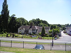
 The Spode Cottage Pub, Armitage | |
 | |
| Coordinates: 52°44′28″N 1°52′16″W / 52.74111°N 1.87111°W | |
| Country | England |
| Primary council | Lichfield |
| County | Staffordshire |
| Region | West Midlands |
| Status | Parish |
| Main settlements | Armitage, Handsacre |
| Government | |
| • Type | Parish Council |
| • UK Parliament | Lichfield |
| Population (2011)[1] | |
• Total | 5,335 |
| Area code | WS |
Armitage with Handsacre or just Armitage[2] is a civil parish[3] in the Lichfield district of Staffordshire, England. It includes the villages of Armitage and Handsacre, and in 2001 had a population of 5,181,[4] rising to 5,335 at the 2011 Census.
The parish's northern border is the River Trent and the town of Rugeley, south of Mavesyn Ridware. To the east it borders Kings Bromley, to the south Longdon and Lichfield to the west Brereton and Ravenhill areas of Rugeley.
There are 19 listed buildings in Armitage with Handsacre
- ^ "Civil Parish population 2011". Retrieved 2 December 2015.
- ^ "Relationships and changes Armitage CP/AP through time". A Vision of Britain through Time. Retrieved 18 February 2023.
- ^ Cite error: The named reference
ons-cpwas invoked but never defined (see the help page). - ^ Cite error: The named reference
ons-popwas invoked but never defined (see the help page).