Back إدارة أرتيبونيت Arabic Artibonit (departament) Azerbaijani Département de l'Artibonite CEB Artibonite (Haiti) Danish Département Artibonite German Departemento Artibonite Esperanto Departamento Artibonito Spanish شهرستان آرتیبونیت Persian Artibonite (departementti) Finnish Artibonite (département) French
Artibonite
Latibonit | |
|---|---|
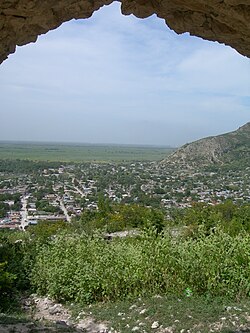
 Dessalines, Artibonite | |
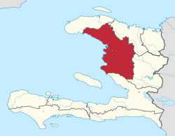
 Artibonite in Haiti | |
| Country | |
| Capital | Gonaïves |
| Region | Artibonite |
| Symbole | Dessalines Coat of Arm |
| Government | |
| • Type | Departmental Council |
| Area | |
| 4,986.94 km2 (1,925.47 sq mi) | |
| Population (2015)[1] | |
| 1,727,524 | |
| • Density | 350/km2 (900/sq mi) |
| • Urban | 739,787 |
| • Rural | 987,737 |
| Time zone | UTC-05:00 (EST) |
| • Summer (DST) | UTC-04:00 (EDT) |
| ISO 3166 code | HT-AR |
| HDI (2017) | 0.469[2] low · 7th |
Artibonite (French pronunciation: [aʁtibɔnit]; Haitian Creole: Latibonit) is one of the ten departments of Haiti located in central Haiti. With an area of 4,887 km2 it is Haiti's largest department. As of 2015, its estimated population was 1,727,524.[3] The region is the country's main rice-growing area. The main cities are Gonaïves (the capital) and Saint-Marc. In February 2004 an insurgency tried unsuccessfully to declare Artibonite's independence.
- ^ "Estimated Pop Total 2015" (PDF). Archived from the original (PDF) on 2015-11-06. Retrieved 2017-06-20.
- ^ "Sub-national HDI - Area Database - Global Data Lab". hdi.globaldatalab.org. Retrieved 2018-09-13.
- ^ "POPULATION TOTALE, POPULATION DE 18 ANS ET PLUS MÉNAGES ET DENSITÉS ESTIMÉS EN 2015" (PDF). IHSI. Archived from the original (PDF) on 2015-11-06. Retrieved 22 Mar 2017.