Back مقاطعة أثينز (أوهايو) Arabic آتنز بؤلگهسی، اوهایو AZB Athens County, Ohio BAR Атънс (окръг, Охайо) Bulgarian এথেন্স কাউন্টি, ওহাইও BPY Athens Gông (Ohio) CDO Атенс (гуо) CE Athens County CEB Athens County, Ohio Welsh Athens County Danish
Athens County | |
|---|---|
 The Athens County court house in Athens | |
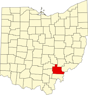
 Location within the U.S. state of Ohio | |
 Ohio's location within the U.S. | |
| Coordinates: 39°20′N 82°03′W / 39.33°N 82.05°W | |
| Country | |
| State | |
| Founded | March 1, 1805[1] |
| Named for | Athens, Greece |
| Seat | Athens |
| Largest city | Athens |
| Area | |
• Total | 508 sq mi (1,320 km2) |
| • Land | 504 sq mi (1,310 km2) |
| • Water | 4.8 sq mi (12 km2) 1.0% |
| Population (2020) | |
• Total | 62,431 |
• Estimate (2022) | 58,979 |
| • Density | 120/sq mi (50/km2) |
| Time zone | UTC−5 (Eastern) |
| • Summer (DST) | UTC−4 (EDT) |
| Congressional district | 12th |
| Website | www |

Athens County is a county in southeastern Ohio. As of the 2020 census, the population was 62,431.[2] Its county seat and largest city is Athens.[3] The county was formed in 1805 from Washington County. Because Ohio's first state university, Ohio University, was established here in 1804, the town and the county are named for the ancient center of learning, Athens, Greece.[4]
Athens County comprises the Athens, OH Micropolitan Statistical Area.
- ^ "Ohio: Individual County Chronologies". Ohio Atlas of Historical County Boundaries. The Newberry Library. 2007. Archived from the original on April 6, 2016. Retrieved February 12, 2015.
- ^ "State & County QuickFacts". United States Census Bureau. Retrieved September 6, 2023.
- ^ "Find a County". National Association of Counties. Archived from the original on May 31, 2011. Retrieved June 7, 2011.
- ^ "Athens County data". Ohio State University Extension Data Center. Retrieved April 28, 2007.[dead link]

