| Avonmouth Docks | |
|---|---|
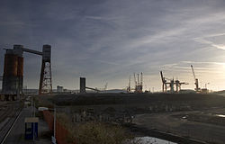
 The docks, as seen from St Andrews Road. The coal loading silos can be seen on the left, with the Avonmouth container terminal on the right | |
 Click on the map for a fullscreen view | |
| Location | |
| Country | United Kingdom |
| Location | Mouth of the River Avon, Bristol, England |
| Coordinates | 51°30′18″N 2°42′25″W / 51.505°N 2.707°W |
| Details | |
| Opened | 1877 |
| Operated by | The Bristol Port Company (150 year lease from 1991) |
| Owned by | Bristol City Council |
| Type of harbour | Artificial |
| Statistics | |
| Website http://www.bristolport.co.uk/ | |
The Avonmouth Docks are part of the Port of Bristol, in England. They are situated on the northern side of the mouth of the River Avon, opposite the Royal Portbury Dock on the southern side, where the river joins the Severn estuary, within Avonmouth.
Accessible via a 210 metres (690 ft) long and 30 metres (98 ft) wide lock, today the docks are one of the UK's major ports for chilled foods, especially fruit and vegetables. Land-side freight access and distribution is via either the M5 motorway or the Henbury Loop Line, whilst rail-passenger access is via Avonmouth railway station on the Severn Beach Line.[1]
