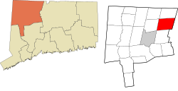
Back Barkhamsted Catalan Баркгемстед (Коннектикут) CE Barkhamsted, Connecticut Welsh Barkhamsted Spanish Barkhamsted (Connecticut) Basque Barkhamsted French Barkhamsted, Connecticut HT Barkhamsted Italian Бархамстед (Коннектикут) Kazakh Бархамстед (Коннектикут) Kirghiz
Barkhamsted, Connecticut | |
|---|---|
 View of the Barkhamsted Reservoir | |
| Coordinates: 41°55′45″N 72°58′20″W / 41.92917°N 72.97222°W | |
| Country | |
| U.S. state | |
| County | Litchfield |
| Region | Northwest Hills |
| Incorporated | 1779 |
| Government | |
| • Type | Selectman-town meeting |
| • First Selectman | Donald S. Stein (D) |
| • Selectman | Raymond P. Pech (D) |
| • Selectman | Nicholas A. Lukiwsky (R) |
| Area | |
• Total | 38.8 sq mi (100.6 km2) |
| • Land | 36.3 sq mi (93.9 km2) |
| • Water | 2.6 sq mi (6.7 km2) |
| Elevation | 607 ft (185 m) |
| Population (2020)[2] | |
• Total | 3,647 |
| • Density | 100/sq mi (38.8/km2) |
| Time zone | UTC−5 (Eastern) |
| • Summer (DST) | UTC−4 (Eastern) |
| ZIP code | 06063, 06065 |
| Area codes | 860/959 |
| FIPS code | 09-02760 |
| GNIS feature ID | 0213386[1] |
| Website | barkhamsted |
Barkhamsted (/bɑːrkˈhæmstɛd/ bark-HAM-sted) is a town in Litchfield County, Connecticut, United States. It contains seven villages: West Hill, Mallory, Barkhamsted Center, Center Hill, Washington Hill, Pleasant Valley, and Riverton. The population was 3,647 at the 2020 census,[3] down from 3,799 at the 2010 census. The town is part of the Northwest Hills Planning Region. Barkhamsted was first incorporated in 1779, and named after Berkhamsted, Hertfordshire, England.[4][5]
- ^ a b U.S. Geological Survey Geographic Names Information System: Barkhamsted, Connecticut
- ^ U.S. Census Bureau Population Estimates
- ^ "Census - Geography Profile: Barkhamsted town, Litchfield County, Connecticut". United States Census Bureau. Retrieved November 26, 2021.
- ^ "Connecticut Towns in the Order of their Establishment". www.sots.ct.gov. Archived from the original on March 14, 2008. Retrieved January 11, 2022.
- ^ The Connecticut Magazine: An Illustrated Monthly. Connecticut Magazine Company. 1903. p. 330.


