Back Blewbury (lungsod) CEB Blewbury Welsh Blewbury Spanish Blewbury Basque Blewbury French Blewbury Italian Blewbury LLD Blewbury Dutch Blewbury Polish Blewbury Swedish
| Blewbury | |
|---|---|
 Blewbury | |
Location within Oxfordshire | |
| Area | 19.24 km2 (7.43 sq mi) |
| Population | 1,657 (2011 Census) |
| • Density | 86/km2 (220/sq mi) |
| OS grid reference | SU5385 |
| Civil parish |
|
| District | |
| Shire county | |
| Region | |
| Country | England |
| Sovereign state | United Kingdom |
| Post town | Didcot |
| Postcode district | OX11 |
| Dialling code | 01235 |
| Police | Thames Valley |
| Fire | Oxfordshire |
| Ambulance | South Central |
| UK Parliament | |
| Website | Blewbury |
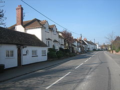
Blewbury is a village and civil parish at the foot of the Berkshire Downs section of the North Wessex Downs about 4 miles (6.4 km) south of Didcot, 14 miles (23 km) south of Oxford and 50 miles (80 km) west of London. It was part of Berkshire until the 1974 boundary changes transferred it to Oxfordshire. The 2011 Census recorded the parish's population as 1,581.[1] A number of springs rise at the foot of the escarpment of the downs. Some springs feed a small lake called the Watercress Beds, where watercress used to be grown. From here and elsewhere tributaries feed the Mill Brook which carries the water to the river Thames at Wallingford. The A417 road runs along below the escarpment above the springs and through the south of the village. The Blewbury citizens are often called Blewbarians.
- ^ "Area: Blewbury (Parish): Key Figures for 2011 Census: Key Statistics". Neighbourhood Statistics. Office for National Statistics. Archived from the original on 10 October 2016. Retrieved 6 June 2015.
