Back بریوستر، ماساچوست AZB Brewster (Massachusetts) Catalan Брюстер (Массачусетс) CE Brewster (lungsod sa Tinipong Bansa, Massachusetts) CEB Brewster, Massachusetts Welsh Brewster (Massachusetts) German Brewster (Massachusetts) Spanish Brewster (Massachusetts) Basque بروستر، ماساچوست Persian Brewster (Massachusetts) French
Brewster, Massachusetts | |
|---|---|
 Linnell Landing Beach, on Cape Cod Bay | |
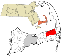
 Location in Barnstable County and the state of Massachusetts | |
| Coordinates: 41°45′36″N 70°05′00″W / 41.76000°N 70.08333°W | |
| Country | United States |
| State | Massachusetts |
| County | Barnstable |
| Settled | 1656 |
| Incorporated | 1803 |
| Communities |
|
| Government | |
| • Type | Open town meeting |
| Area | |
• Total | 25.4 sq mi (65.9 km2) |
| • Land | 22.9 sq mi (59.3 km2) |
| • Water | 2.5 sq mi (6.6 km2) |
| Elevation | 39 ft (12 m) |
| Population (2020) | |
• Total | 10,318 |
| • Density | 451/sq mi (174.0/km2) |
| Time zone | UTC−5 (Eastern) |
| • Summer (DST) | UTC−4 (Eastern) |
| ZIP Code | 02631 |
| Area code | 508 / 774 |
| FIPS code | 25-07980 |
| GNIS feature ID | 0618249 |
| Website | www |
Brewster /ˈbruːstər/ is a town in Barnstable County, Massachusetts, United States, Barnstable County being coextensive with Cape Cod. The population of Brewster was 10,318 at the 2020 census.[1]
Initially settled in 1659, the Town of Brewster is named after Elder William Brewster, the religious leader of Plymouth Colony. Brewster is known as the "Sea Captain's Town" for its wealth of eighteenth and nineteenth century historic captain's homes, including the Cobb House (1799), the current home of the Brewster Historical Society.[2][3]
Brewster is also notable as the home of Nickerson State Park, a 1,900 acre preserve carved out of the former hunting grounds of the prominent Nickerson Family.[4][5] The impact of the Nickerson Family can be seen at the Nickerson Mansion, now the home of Ocean Edge Resort. Constructed in 1890, the structure known as Fieldstone Hall was considered one of the most expensive houses built in the country at that time.[4]
The town is a popular summer destination, with the town population increasing to 30,000.[6] It also contains two National Historic Districts: Brewster Old King's Highway Historic District and Stony Brook–Factory Village Historic District, both listed on the National Register of Historic Places.[7]
Brewster is twinned with the town of Budleigh Salterton in the United Kingdom.
- ^ "Census – Geography Profile: Brewster town, Barnstable County, Massachusetts". U.S. Census Bureau. Retrieved October 6, 2021.
- ^ "Things You Might Not Know About Brewster". CapeCod.com. August 17, 2023. Retrieved September 14, 2023.
- ^ "Captain Cobb House". Brewster Historical Society. Retrieved September 14, 2023.
- ^ a b "Historic Hotels of America". Historic Hotels Worldwide. Retrieved September 14, 2023.
- ^ "Nickerson State Park | Mass.gov". www.mass.gov. Retrieved September 14, 2023.
- ^ "Our Community | Town of Brewster". www.brewster-ma.gov. Retrieved September 14, 2023.
- ^ "Old King's Highway Regional Historic District Committee | Town of Brewster". www.brewster-ma.gov. Retrieved September 14, 2023.

