Back কাম্পো আলেগ্রে BPY Кампу-Алегри (Алагоас) CE Campo Alegre (munisipyo sa Brasil, Alagoas, lat -9,79, long -36,29) CEB Campo Alegre (Alagoaso) Esperanto Campo Alegre (Alagoas) Basque Campo Alegre (Alagoas) French Կամպու Ալեգրի (Ալագոաս) Armenian Campo Alegre, Alagoas ID Campo Alegre (Alagoas) Italian Кампу-Алегри Kazakh
You can help expand this article with text translated from the corresponding article in Portuguese. Click [show] for important translation instructions.
|
Campo Alegre | |
|---|---|
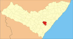
 Location of Campo Alegre in Alagoas | |
| Coordinates: 9°46′55″S 36°21′3″W / 9.78194°S 36.35083°W | |
| Country | |
| Region | Northeast |
| State | |
| Founded | 8 June 1960[2] |
| Government | |
| • Mayor | Nicolas Teixeira Tavares Pereira (PP) (2021-2024)[3][4] |
| • Vice Mayor | Leonardo de Paula Monteiro (PP) (2021-2024)[4] |
| Area | |
• Total | 312.726 km2 (120.744 sq mi) |
| Elevation | 106 m (348 ft) |
| Population (2022) | |
• Total | 32,106[1] |
| • Density | 102.66/km2 (265.9/sq mi) |
| Demonym | Campo-alegrense (Brazilian Portuguese)[1] |
| Time zone | UTC-03:00 (Brasília Time) |
| Postal code | 57250-000, 57254-000[5] |
| HDI (2010) | 0.570 – medium[1] |
| Website | campoalegre.al.gov.br |
Campo Alegre is a municipality located in the Brazilian state of Alagoas. Its population is 57,537 (2020 est)[6] and its area is 308 km2 (119 sq mi).[7]
- ^ a b c "Campo Alegre". Instituto Brasileiro de Geografia e Estatística (in Brazilian Portuguese). Instituto Brasileiro de Geografia e Estatística. Retrieved 18 December 2024.
- ^ "História & Fotos". Instituto Brasileiro de Geografia e Estatística (in Brazilian Portuguese). Instituto Brasileiro de Geografia e Estatística. Retrieved 18 December 2024.
- ^ "Gabinete do Prefeito". Prefeitura Municipal de Campo Alegre - AL (in Brazilian Portuguese). Prefeitura Municipal de Campo Alegre - AL. Retrieved 18 December 2024.
- ^ a b "Prefeito e vereadores de Campo Alegre tomam posse; veja lista de eleitos". G1 (in Brazilian Portuguese). Globo. Retrieved 18 December 2024.
- ^ "Código Postal Campo Alegre/AL - Brasil". Código Postal (in Spanish). Código Postal. Retrieved 18 December 2024.
- ^ IBGE 2020
- ^ IBGE - "Archived copy". Archived from the original on 11 June 2008. Retrieved 11 June 2008.
{{cite web}}: CS1 maint: archived copy as title (link)


