Back Cher (département) Afrikaans Département Cher ALS Char AN شار (إقليم فرنسي) Arabic Şer (departament) Azerbaijani Département Cher BAR Шэр (дэпартамент) Byelorussian Шэр (дэпартамэнт) BE-X-OLD Шер (департамент) Bulgarian Cher (departamant) Breton
You can help expand this article with text translated from the corresponding article in French. (January 2009) Click [show] for important translation instructions.
|
Cher
Char | |
|---|---|
 Prefecture building in Bourges | |
|
| |
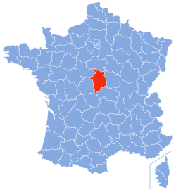
 Location of Cher in France | |
| Coordinates: 47°0′N 2°35′E / 47.000°N 2.583°E | |
| Country | France |
| Region | Centre-Val de Loire |
| Prefecture | Bourges |
| Subprefectures | Saint-Amand-Montrond Vierzon |
| Government | |
| • President of the Departmental Council | Jacques Fleury[1] (LR) |
| Area | |
• Total | 7,235 km2 (2,793 sq mi) |
| Population (2022)[2] | |
• Total | 299,496 |
| • Rank | 76th |
| • Density | 41/km2 (110/sq mi) |
| Time zone | UTC+1 (CET) |
| • Summer (DST) | UTC+2 (CEST) |
| Department number | 18 |
| Arrondissements | 3 |
| Cantons | 19 |
| Communes | 287 |
| ^1 French Land Register data, which exclude estuaries and lakes, ponds and glaciers larger than 1 km2 | |
Cher (/ʃɛər/ SHAIR, French: [ʃɛʁ] ⓘ; Berrichon: Char) is a department in central France, part of the Centre-Val de Loire region. Named after the river Cher, its prefecture is Bourges. In 2019, it had a population of 302,306.[3]
- ^ "Répertoire national des élus: les conseillers départementaux". data.gouv.fr, Plateforme ouverte des données publiques françaises (in French). 4 May 2022.
- ^ "Populations de référence 2022" (in French). The National Institute of Statistics and Economic Studies. 19 December 2024.
- ^ Populations légales 2019: 18 Cher, INSEE

