Back چیکاقو لوپ AZB শিকাগো লুপ Bengali/Bangla Chicago Loop CEB Chicago Loop Czech Chicago Loop German Chicago Loop Spanish Chicago Loop Basque شیکاگو لوپ Persian Loop (Chicago) French Chicago Loop Frisian
The Loop | |
|---|---|
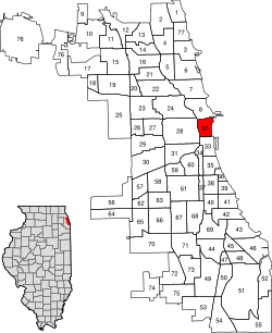
| Community Area 32 – The Loop | |
 | |
 Interactive street map | |
 Location within the city of Chicago | |
| Coordinates: 41°52′52″N 87°37′47″W / 41.88111°N 87.62972°W[1] | |
| Country | United States |
| State | Illinois |
| County | Cook |
| City | Chicago |
| Neighborhoods | |
| Area | |
• Total | 1.58 sq mi (4.09 km2) |
| Elevation | 594 ft (181 m) |
| Population (2020)[2] | |
• Total | 42,298 |
| • Density | 27,000/sq mi (10,000/km2) |
| population up 158.1% from 2000 | |
| Demographics 2021[2] | |
| • White | 56.7% |
| • Black | 8.1% |
| • Hispanic | 10.4% |
| • Asian | 20.9% |
| • Other | 4.0% |
| Educational Attainment 2021[2] | |
| • High School Diploma or Higher | 97.3% |
| • Bachelor's Degree or Higher | 82.2% |
| Time zone | UTC-6 (CST) |
| • Summer (DST) | UTC-5 (CDT) |
| ZIP codes | 60601, 60602, 60603, 60604, and parts of 60605, 60606, 60607, and 60616 |
| Median household income 2021 | $115,988[2] |
| Source: U.S. Census, Record Information Services [clarification needed] | |
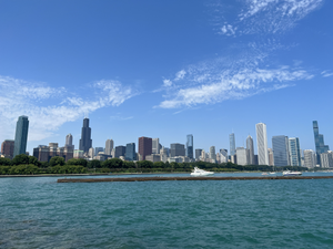
The Loop is Chicago's central business district and one of the city's 77 municipally recognized community areas. Located at the center of downtown Chicago[3] on the shores of Lake Michigan, it is the second-largest business district in North America after Midtown Manhattan. The headquarters and regional offices of several global and national businesses, retail establishments, restaurants, hotels, and theaters–as well as many of Chicago's most famous attractions–are located in the Loop.[4] The neighborhood also hosts Chicago's City Hall, the seat of Cook County, offices of other levels of government, and several foreign consulates. The intersection of State Street and Madison Street in the Loop is the origin point for the address system on Chicago's street grid.
The Loop's definition and perceived boundaries have developed over time. Since the 1920s, the area bounded by the Chicago River to the west and north, Lake Michigan to the east, and Roosevelt Road (12th Street) to the south is called the Loop. It took its name from a somewhat smaller area, which meant the 35 city blocks bounded on the north by Lake Street, on the west by Wells Street, on the south by Van Buren Street, and on the east by Wabash Avenue—the Union Loop formed by the 'L' in the late 1800s.[5] Similarly, "South" and "West Loop" historically referred to areas within the Loop proper, but in the 21st century began to refer to the entire Near South and much of the Near West Sides of the city, respectively.[6][7]
In 1803, the United States Army built Fort Dearborn in what is now the Loop; although earlier settlement was present, this was first settlement in the area sponsored by the United States' federal government. When Chicago and Cook County were incorporated in the 1830s, the area was selected as the site of their respective seats. Originally mixed-use, the neighborhood became increasingly commercial in the 1870s. This process accelerated in the aftermath of the 1871 Great Chicago Fire, which destroyed most of the neighborhood's buildings. Some of the world's earliest skyscrapers were constructed in the Loop, giving rise to the Chicago School of architecture. By the late 19th century, cable car turnarounds and the Union Loop encircled the area, giving the neighborhood its name. Near the lake, Grant Park "Chicago's front yard" is Chicago's oldest park but was significantly expanded in the late 19th and early 20th centuries and houses a number of features and museums. Starting in the 1920s, road improvements for highways were constructed to and into the Loop, perhaps most famously U.S. Route 66, which opened in 1926.
While dominated by offices and public buildings, its residential population boomed during the latter 20th century and first decades of the 21st, partly due to the development of former rail yards (at one time, the area had six major interurban railroad terminals and land was also needed for extensive rail cargo storage and transfer), industrial lands, as well as highrise residences. Since 1950, the Loop's population has increased the most out of all of Chicago's community areas.
- ^ a b "Chicago Loop". Geographic Names Information System. United States Geological Survey, United States Department of the Interior. January 15, 1980.
- ^ a b c d "Community Data Snapshot - Loop" (PDF). cmap.illinois.gov. MetroPulse. Archived (PDF) from the original on June 28, 2018. Retrieved November 17, 2023.
- ^ "The Loop". britannica.com. Encyclopedia Britannica. Retrieved September 9, 2024.
- ^ "Top Ten Largest CBDs in the USA". Retrieved August 30, 2024.
- ^ "The Loop". britannica.com. Encyclopedia Britannica. Retrieved September 9, 2024.
- ^ Matthews, David (August 25, 2015). "Where Does The South Loop Start and End? Borders a Work in Progress". Block Club Chicago. Retrieved September 9, 2024.
- ^ Harrington, Adam (June 14, 2023). "What is the Loop in Chicago?". CBS News Chicago. Retrieved September 9, 2024.