Back مقاطعة تشيتا Arabic Çita vilayəti Azerbaijani Чыцінская вобласць Byelorussian Читинска област Bulgarian Óblast de Txità Catalan Čitská oblast Czech Tjita oblast Danish Oblast Tschita German Περιφέρεια Τσιτά Greek Óblast de Chitá Spanish
| Chita Oblast | |||||||
|---|---|---|---|---|---|---|---|
| Oblast of Russia | |||||||
| 1937–2008 | |||||||
 | |||||||
| History | |||||||
• Established | 26 September 1937 | ||||||
• Disestablished | 1 March 2008 | ||||||
| |||||||
| Today part of | Russia · Zabaykalsky Krai | ||||||
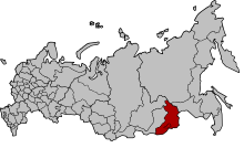
Chita Oblast (Russian: Чити́нская о́бласть, romanized: Čitínskaja óblastj, IPA: [tɕɪˈtʲinskəjə ˈobləsʲtʲ]) was a federal subject of Russia (an oblast) in southeast Siberia, Russia. Its administrative center was the city of Chita. It had extensive international borders with China (998 km) and Mongolia (868 km) and internal borders with Irkutsk and Amur Oblasts, as well as with the republics of Buryatia and Yakutia. Its area was 431,500 square kilometers (166,600 sq mi). Population: 1,155,346 (2002 Census);[1] 1,377,975 (1989 Soviet census).[2]
The oblast was established on September 26, 1937. On March 1, 2008, Chita Oblast merged with Agin-Buryat Autonomous Okrug to form Zabaykalsky Krai.
The territory that made up the former Chita Oblast was first explored by Cossacks led by Pyotr Beketov in 1653. People began to move into and develop the area in order to strengthen Russia's border with China and Mongolia, extract mineral resources, and build the Trans-Siberian Railway. In 1920, Chita became the capital of the Far East Republic, which merged with Russia in November 1922, a month before the USSR was constituted.
The oblast was rich in ferrous, non-ferrous, rare, and precious metals, coal, charcoal, and mineral waters. Russia's estimated reserves of ores with a high uranium content are 145,400 tons. Most of these deposits are located in the former Chita Oblast, near Krasnokamensk, site of the Priargunsky Mining and Chemical Combine (PMCC).[3] Forests cover about 60% of its territory. As a result, the oblast's main industries were metallurgy, fuel, and timber. It also had advanced light and food industries. Local agriculture focused on cattle, sheep, and reindeer breeding.
- ^ Federal State Statistics Service (21 May 2004). Численность населения России, субъектов Российской Федерации в составе федеральных округов, районов, городских поселений, сельских населённых пунктов – районных центров и сельских населённых пунктов с населением 3 тысячи и более человек [Population of Russia, Its Federal Districts, Federal Subjects, Districts, Urban Localities, Rural Localities—Administrative Centers, and Rural Localities with Population of Over 3,000] (XLS). Всероссийская перепись населения 2002 года [All-Russia Population Census of 2002] (in Russian).
- ^ Всесоюзная перепись населения 1989 г. Численность наличного населения союзных и автономных республик, автономных областей и округов, краёв, областей, районов, городских поселений и сёл-райцентров [All Union Population Census of 1989: Present Population of Union and Autonomous Republics, Autonomous Oblasts and Okrugs, Krais, Oblasts, Districts, Urban Settlements, and Villages Serving as District Administrative Centers]. Всесоюзная перепись населения 1989 года [All-Union Population Census of 1989] (in Russian). Институт демографии Национального исследовательского университета: Высшая школа экономики [Institute of Demography at the National Research University: Higher School of Economics]. 1989 – via Demoscope Weekly.
- ^ https://web.archive.org/web/20061215042936/http://www.nti.org/db/nisprofs/russia/fissmat/minemill/overview.htm [bare URL]

