Back مقاطعة كوك (مينيسوتا) Arabic Cook County, Minnesota BAR Кук (окръг, Минесота) Bulgarian কোক কাউন্টি, মিনেসোটা BPY Cook Gông (Minnesota) CDO Cook County (kondado sa Tinipong Bansa, Minnesota) CEB Cook County, Minnesota Welsh Cook County (Minnesota) Danish Cook County (Minnesota) German Κομητεία Κουκ (Μινεσότα) Greek
Cook County | |
|---|---|
 | |
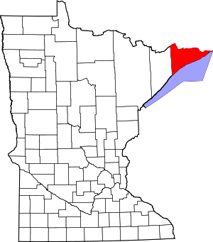
 Location within the U.S. state of Minnesota | |
 Minnesota's location within the U.S. | |
| Coordinates: 47°55′00″N 90°33′00″W / 47.916666666667°N 90.55°W | |
| Country | |
| State | |
| Founded | March 9, 1874 |
| Named for | Michael Cook |
| Seat | Grand Marais |
| Largest city | Grand Marais |
| Area | |
• Total | 3,340 sq mi (8,700 km2) |
| • Land | 1,452 sq mi (3,760 km2) |
| • Water | 1,887 sq mi (4,890 km2) 57% |
| Population (2020) | |
• Total | 5,600 |
• Estimate (2023) | 5,639 |
| • Density | 1.7/sq mi (0.65/km2) |
| Time zone | UTC−6 (Central) |
| • Summer (DST) | UTC−5 (CDT) |
| Congressional district | 8th |
| Website | www |
Cook County is the easternmost county in the U.S. state of Minnesota. As of the 2020 census, the population was 5,600,[1] making it Minnesota's seventh-least populous county. Its county seat is Grand Marais.[2] The Grand Portage Indian Reservation is in the county.
- ^ "State & County QuickFacts". United States Census Bureau. Retrieved April 20, 2023.
- ^ "Find a County". National Association of Counties. Archived from the original on May 31, 2011. Retrieved June 7, 2011.