| Adelaide South Australia | |||||||||||||||
|---|---|---|---|---|---|---|---|---|---|---|---|---|---|---|---|
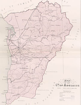
 Map of Adelaide County in 1886 showing the hundreds | |||||||||||||||
| Established | 2 June 1842[1] | ||||||||||||||
| Area | 2,960 square kilometres (1,141 sq mi)[2] | ||||||||||||||
| |||||||||||||||
| Footnotes | Adjoining counties[3] | ||||||||||||||
The County of Adelaide is one of the 49 cadastral counties of South Australia and contains the city of Adelaide.[2][4] It was proclaimed on 2 June 1842 by Governor Grey. It is bounded by the Gawler River and North Para River in the north, the Mount Lofty Ranges in the east, and Gulf St Vincent in the west. The south border runs from Aldinga Bay to Willunga South and Mount Magnificent.
The county held at least 60% of South Australia's population between 1855 and 1921; this figure rose to 70.6% in 1966.[5]
- ^ Jackson, J. Alex (2 June 1842). "untitled (division of province into counties)" (PDF). South Australian Government Gazette. 1842. Government of South Australia: 1. Retrieved 18 December 2016.
- ^ a b "'Search for County of Adelaide, CNTY'". Property Location Browser. SA0000278. Archived from the original on 7 December 2015. Retrieved 24 April 2017.
Other details: Area 1141 square miles
- ^ "Hundred Map Series Index Map" (PDF). Hundred Map Series. Department of Environment and Heritage, Government of South Australia. December 2008. Retrieved 16 November 2015.
- ^ "Place Names SA, County of Adelaide". Government of South Australia. Archived from the original on 30 September 2007.
{{cite web}}: CS1 maint: bot: original URL status unknown (link) - ^ "Population change". Atlas South Australia. Archived from the original on 23 February 2008.
