Back مقاطعة كوليتز (واشنطن) Arabic Cowlitz County, Washington BAR Каулиц (окръг) Bulgarian কাউলিটজ কাউন্টি, ৱাশিংটন BPY Cowlitz Gông (Washington) CDO Каулиц (гуо, Вашингтон) CE Cowlitz County CEB Cowlitz County Czech Cowlitz County, Washington Welsh Cowlitz County German
Cowlitz County | |
|---|---|
 Cowlitz County Courthouse | |
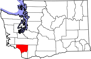
 Location within the U.S. state of Washington | |
 Washington's location within the U.S. | |
| Coordinates: 46°11′48″N 122°40′42″W / 46.19667°N 122.67833°W | |
| Country | |
| State | |
| Founded | April 21, 1854 |
| Seat | Kelso |
| Largest city | Longview |
| Area | |
• Total | 1,166 sq mi (3,020 km2) |
| • Land | 1,140 sq mi (3,000 km2) |
| • Water | 26 sq mi (70 km2) 2.2% |
| Population (2020) | |
• Total | 110,730 |
• Estimate (2023) | 112,864 |
| • Density | 95/sq mi (37/km2) |
| Time zone | UTC−8 (Pacific) |
| • Summer (DST) | UTC−7 (PDT) |
| Congressional district | 3rd |
| Website | co.cowlitz.wa.us |
Cowlitz County is a county located in the U.S. state of Washington. As of the 2020 census, its population was 110,730.[1] The county seat is Kelso,[2] and its largest city is Longview. The county was formed in April 1854.[3] Its name derives from the anglicized version of the Cowlitz Indian term Cow-e-liske, meaning either 'river of shifting sands' or 'capturing the medicine spirit.'[citation needed] Cowlitz comprises the Longview, WA Metropolitan statistical area, which is also included in the Portland-Vancouver-Salem, OR-WA Combined statistical area.[4]
- ^ "State & County QuickFacts". United States Census Bureau. Retrieved November 10, 2024.
- ^ "Find a County". National Association of Counties. Archived from the original on May 31, 2011. Retrieved June 7, 2011.
- ^ "Milestones for Washington State History — Part 2: 1851 to 1900". HistoryLink.org. March 6, 2003.
- ^ "Revised Delineations of Metropolitan Statistical Areas, Micropolitan Statistical Areas, and Combined Statistical Areas, and Guidance on Uses of the Delineations of These Areas" (PDF). Office of Management and Budget. February 28, 2013. Archived (PDF) from the original on January 21, 2017. Retrieved July 5, 2015.