Back كوينكا Arabic مدينه كوينكا ARZ Kuenka (Ekvador) Azerbaijani Куэнка (Эквадор) Byelorussian Куэнка (Эквадор) BE-X-OLD কুয়েন্কা (ইকুয়েডর) Bengali/Bangla Cuenca (Equador) Catalan کوێنکا CKB Cuenca (Ekvádor) Czech Cuenca (Ecuador) Danish
This article needs additional citations for verification. (January 2019) |
Cuenca | |
|---|---|
City | |
| Santa Ana de los Ríos de Cuenca | |
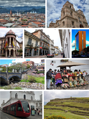
 From top, left to right: Panoramic view of the Historic Center, Cathedral of the Immaculate Conception, City hall of Cuenca, Simon Bolívar Street, Cuenca Chamber of Commerce, Roto Bridge, Flowers Square, Cuenca Tram and archaeological ruins of Pumapungo. | |
| Nickname: Atenas del Ecuador (Athens of Ecuador) | |
| Coordinates: 2°53′50.69″S 79°00′16.13″W / 2.8974139°S 79.0044806°W | |
| Country | |
| Province | |
| Canton | Cuenca Canton |
| Founded | April 12, 1557 |
| Founded by | Gil Ramírez Dávalos |
| Named for | Cuenca, Spain |
| Parishes | Urban Parishes
|
| Government | |
| • Mayor | Cristian Zamora |
| Area | |
• City | 3,195 km2 (1,234 sq mi) |
| • Urban | 71.45 km2 (27.59 sq mi) |
| • Canton | 3,195 km2 (1,234 sq mi) |
| Elevation | 2,560 m (8,400 ft) |
| Highest elevation | 2,550 m (8,370 ft) |
| Lowest elevation | 2,350 m (7,710 ft) |
| Population (2022 census)[2] | |
• City | 596,101 |
| • Rank | 3rd in Ecuador |
| • Density | 190/km2 (480/sq mi) |
| • Urban | 361,524[1] |
| • Urban density | 5,060/km2 (13,100/sq mi) |
| Demonym | Cuencan |
| GDP (PPP, constant 2015 values) | |
| • Year | 2023 |
| • Total | $6.5 billion[3] |
| • Per capita | $14,600 |
| Time zone | UTC-5 (ECT) |
| Postal code | EC010150 |
| Area code | (+593) 07 |
| Climate | Marine |
| Website | Official website (in Spanish) |
Cuenca, officially Santa Ana de los Ríos de Cuenca, is an Ecuadorian city, head of the canton of the same name and capital of the province of Azuay, as well as its largest and most populated city. It is crossed by the Tomebamba, Tarqui, Yanuncay and Machángara rivers,[4] in the south-central inter-Andean region of Ecuador, in the Paute river basin, at an altitude of 2,538 meters above sea level[5] and with a temperate Andean climate averaging 16.3 °C.
It has been locally called "Cuenca of the Andes" or "Athens of Ecuador"[6][7] for its architecture, its cultural diversity, its contribution to Ecuadorian arts, sciences and literature, and for being the birthplace of many illustrious figures of Ecuadorian society.[7][6] At the 2022 census it had a population of 596,101 inhabitants,[2] making it the third most populous city in the country behind Guayaquil and Quito. The city is the core of the Cuenca metropolitan area, which is also made up of nearby rural towns and parishes. The conglomerate also ranks third among Ecuador's conurbations.
It was founded on April 12, 1557, on the ruins of the Inca city of Tomebamba (a major administrative center)[8] and the Cañari city of Guapondelig,[8] by Gil Ramírez Dávalos,[9] under orders of the viceroy of Peru Andrés Hurtado de Mendoza. During the 20th century, the city continued to grow, promoting education and culture, and in 1999 its historic center was declared a UNESCO World Heritage Site.[10] It is one of Ecuador's most important administrative, economic, financial and commercial centers. The city's main activities are commerce and industry; in recent years, Cuenca has also established itself as an international tourist attraction.[citation needed]
- ^ Citypopulation.de Population and area of Cuenca urban area
- ^ a b Marco Carrasco (21 September 2023). "Resultados Censo Ecuador: las 12 ciudades más pobladas del país". Ecuavisa website.
- ^ "TelluBase—Ecuador Fact Sheet (Tellusant Public Service Series)" (PDF). Tellusant. Retrieved 2024-01-11.
- ^ Stephen Vargha (31 July 2023). "The Four Rivers Of Cuenca". YapaTree website.
- ^ Marco Carrasco (21 September 2023). "Visit Cuenca. Generalities". Municipal Tourism Foundation of Cuenca website.
- ^ a b Emma-Jayne Abbots (2017). The Agency of Eating. Mediation, Food and the Body. Bloomsbury Publishing. p. 8. ISBN 978-1-47259-856-1.
- ^ a b Zishan Parks (2019). World Tourism in the New Millennium. EDTECH. p. 177. ISBN 978-1-83947-441-5.
- ^ a b R. Alan Covey, Sonia Alconini (2018). The Oxford Handbook of the Incas. Oxford University Press. p. 397. ISBN 978-0-19-090803-4.
- ^ Antonio de Ulloa; Jorge Juan y Santacilia (1748). Relación histórica del viage. Hecho de orden de S. Mag. a la América Meridional para medir algunos grados del meridiano terreftre y venir por ellos en conocimiento de la verdadera figura y magnitud de la tierra y otras observaciones aftronómicas, y Phísicas. Historical Library of the Complutense University of Madrid: Antonio Marín. p. 656.
- ^ "Historic Centre of Santa Ana de los Ríos de Cuenca". UNESCO World Heritage Centre website.


