Back Cicló Pam Catalan Ciclón Pam Spanish Trooppinen hirmumyrsky Pam Finnish Cyclone Pam French サイクロン・パム Japanese 사이클론 팸 Korean പാം ചുഴലിക്കാറ്റ് Malayalam Siklon Pam Malay Cyklon Pam Polish Ciclone Pam Portuguese
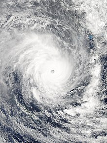
 Pam nearing peak intensity over Vanuatu, on 13 March | |
| Meteorological history | |
|---|---|
| Formed | 6 March 2015 |
| Extratropical | 15 March 2015 |
| Dissipated | 20 March 2015 |
| Category 5 severe tropical cyclone | |
| 10-minute sustained (FMS) | |
| Highest winds | 250 km/h (155 mph) |
| Lowest pressure | 896 hPa (mbar); 26.46 inHg (Third-lowest in South Pacific basin, Fourth-lowest in Southern Hemisphere) |
| Category 5-equivalent tropical cyclone | |
| 1-minute sustained (SSHWS) | |
| Highest winds | 280 km/h (175 mph) |
| Lowest pressure | 911 hPa (mbar); 26.90 inHg |
| Overall effects | |
| Fatalities | 15–16 total |
| Damage | $692 million (Costliest in Vanuatu history)[1] |
| Areas affected | Fiji, Kiribati, Solomon Islands, Tuvalu, Vanuatu, New Caledonia, New Zealand |
| IBTrACS | |
Part of the 2014–15 South Pacific cyclone season | |
Severe Tropical Cyclone Pam was the second most intense tropical cyclone of the South Pacific Ocean in terms of sustained winds and is regarded as one of the worst natural disasters in the history of Vanuatu.[2] A total of 15–16 people died either directly or indirectly as a result of Pam with many others injured. The storm's impacts were also felt, albeit to a lesser extent, on other islands in the South Pacific, most notably the Solomon Islands, Tuvalu, and New Zealand. Pam is the third most intense storm of the South Pacific Ocean according to pressure, after Winston of 2016 and Zoe of 2002. It is also the second most intense tropical cyclone in 2015, only behind Hurricane Patricia. In addition, Pam is tied with Orson, Monica, Marcus and Fantala for having the second strongest ten-minute maximum sustained winds in the Southern Hemisphere. Thousands of homes, schools and buildings were damaged or destroyed, with an estimated 3,300 people displaced as a result.
Pam formed on 6 March, east of the Solomon Islands and tracked slowly in a generally southward direction, slowly intensifying as it did so. Two days later, the disturbance reached tropical cyclone intensity and, over subsequent days, Pam gradually strengthened before reaching Category 5 cyclone status on both the Australian and Saffir–Simpson scales on 12 March. The next day, Pam's sustained winds peaked at 250 km/h (155 mph) as the storm moved through Vanuatu, passing near several constituent islands and making direct hits on others. On 14 March, Pam's winds began to slowly weaken, but its pressure dropped further to a minimum of 896 mbar (hPa; 26.46 inHg) before rising shortly afterwards. Over the next few days, the cyclone's weakening accelerated as it moved poleward. On 15 March, Pam passed northeast of New Zealand before transitioning into an extratropical cyclone that same day.
Early in Pam's history, a damaging storm surge impacted Tuvalu, prompting a state of emergency declaration after 45 percent of the nation's residents were displaced. Torrential rainfall occurred in the southeastern Solomon Islands, particularly in the Santa Cruz Islands. In Vanuatu, all emergency centres were activated and relief personnel were put on standby with Pam assessed as having the potential to be one of the nation's worst tropical cyclones. Catastrophic damage occurred as the storm moved through the archipelago, particularly in Efate, the location of the Ni-Vanuatu capital of Port Vila; and the Tafea islands of Erromango and Tanna. The cyclone crippled Vanuatu's infrastructure: an estimated 90 percent of the nation's buildings were impacted by the storm's effects, telecommunications were paralysed, and water shortages continue to plague the small nation. Pam later brought heavy winds and rough surf to New Zealand's North Island during its weakening stages.
- ^ First Category 5 Tropical Cyclone of 2020, Harold, Pounds Vanuatu, Scientific American, April 6, 2020
- ^ Joshua Robertson (15 March 2015). "Cyclone Pam: Vanuatu awaits first wave of relief and news from worst-hit islands". The Guardian. Retrieved 15 March 2015.