Debagram | |
|---|---|
Village | |
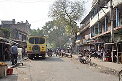
 Tehatta-Bhagirathi Ghat Road | |
| Coordinates: 23°41′N 88°17′E / 23.683°N 88.283°E | |
| Country | |
| State | West Bengal |
| District | Nadia district |
| Named for | Veda sastra |
| Government | |
| • Body | Debagram Gram Panchyat |
| Elevation | 18 m (59 ft) |
| Population (2011) | |
• Total | 32,697 |
| Languages | |
| • Official | Bengali, English |
| Time zone | UTC+5:30 (IST) |
| PIN | 741137 |
| Telephone code | 03474 |
| ISO 3166 code | IN-WB |
| Lok Sabha Constituency | Krishnanagar (Mahua Moitra) |
| Vidhan Sabha Constituency | Kaliganj (Hasanujjaman Mandal) |
Debagram is a village in the Kaliganj CD block in the Krishnanagar Sadar subdivision of the Nadia district in the Indian state of West Bengal.


