Back Taman Nasional Désémbarco dél Granma BAN Дэсэмбарка-дэль-Гранма BE-X-OLD Parc Nacional del Desembarco del Granma Catalan Desembarco del Granma Czech Nationalpark Desembarco del Granma German Parque nacional Desembarco del Granma Spanish Desembarco del Granma Parke Nazionala Basque پارک ملی دسمبارکو دل گرنما Persian Desembarco del Granman kansallispuisto Finnish Parc national Desembarco del Granma French
| Desembarco del Granma National Park | |
|---|---|
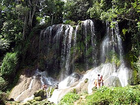
 A waterfall in the national park | |
| Location | Cuba |
| Nearest city | Niquero |
| Coordinates | 19°53′00″N 77°38′00″W / 19.88333°N 77.63333°W |
| Area | 261.80 km2 |
| Established | 1986 |
| Type | Natural |
| Criteria | vii, viii |
| Designated | 1999 (23rd session) |
| Reference no. | 889 |
| Region | Latin America and the Caribbean |
Desembarco del Granma National Park (Spanish: Parque Nacional Desembarco del Granma) is a national park in south-western Cuba, stretching across the Niquero and Pilón municipalities in what is now Granma Province.[1] The name of the park means "Landing of the Granma" and refers to the yacht in which Fidel Castro, Che Guevara, Raúl Castro, and 79 of their supporters sailed from Mexico to Cuba in 1956 and incited the Cuban Revolution.[2] The National park is well known for its karst topography and coastal cliffs.
The national park has a total area of 32,576 ha, of which 26,180 ha are terrestrial and 6,396 ha are marine.[1] In 1999, it was listed by UNESCO as a World Heritage Site because of its uplifted marine terraces and pristine sea cliffs.[1]
- ^ a b c "Desembarco del Granma National Park". UNESCO World Heritage Centre. United Nations Educational, Scientific, and Cultural Organization. Retrieved 28 May 2021.
- ^ System of Marine Terraces of Cabo Cruz and Maisi (PDF) (Report). Republic of Cuba. 1998.
