Back مقاطعة إليزافيتبول Arabic Gəncə quberniyası Azerbaijani Елізаветпальская губерня Byelorussian Елисаветполан губерни CE پارێزگای ئەلیزاڤێتپۆل CKB Elizavetpola Gubernio Esperanto Gobernación de Elizavétpol Spanish فرمانداری الیزابتپل Persian Jelizavetpolin kuvernementti Finnish Gouvernement d'Elisavetpol French
Elizavetpol Governorate
Елисаветпольская губернія | |
|---|---|
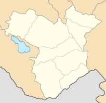
 Administrative map of the Elizavetpol Governorate | |
| Country | Russian Empire |
| Viceroyalty | Caucasus |
| Established | 1867 |
| Abolished | 1920 |
| Capital | Yelisavetpol (present-day Ganja) |
| Area | |
• Total | 44,296.15 km2 (17,102.84 sq mi) |
| Highest elevation | 4,466 m (14,652 ft) |
| Population (1916) | |
• Total | 1,275,131 |
| • Density | 29/km2 (75/sq mi) |
| • Urban | 12.24% |
| • Rural | 87.76% |
| History of Azerbaijan |
|---|
 |
|
|
| History of Armenia |
|---|
 |
| Timeline • Origins • Etymology |
The Elizavetpol Governorate,[a] also known after 1918 as the Ganja Governorate,[b] was a province (guberniya) of the Caucasus Viceroyalty of the Russian Empire, with its capital in Yelisavetpol (present-day Ganja). The area of the governorate stretched 38,922.43 square versts (44,296.15 square kilometres; 17,102.84 square miles) and was composed of 1,275,131 inhabitants in 1916. The Elizavetpol Governorate bordered the Erivan Governorate to the west, the Tiflis Governorate and Zakatal Okrug to the north, the Dagestan Oblast to the northeast, the Baku Governorate to the east, and Iran to the south.
Cite error: There are <ref group=lower-alpha> tags or {{efn}} templates on this page, but the references will not show without a {{reflist|group=lower-alpha}} template or {{notelist}} template (see the help page).
