| Fajada Butte | |
|---|---|
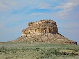
 Fajada Butte mid-morning | |
| Highest point | |
| Elevation | 6,623 ft (2,019 m) NGVD 29[1] |
| Coordinates | 36°01′08″N 107°54′35″W / 36.0189052°N 107.9097837°W[2] |
| Geography | |
| Location | San Juan County, New Mexico, U.S. |
| Topo map | USGS Pueblo Bonito |
| Geology | |
| Rock age | Cretaceous |
| Mountain type | Sandstone |
| Climbing | |
| First ascent | circa 850 AD |
| Easiest route | closed to visitors |
Fajada Butte is a butte in Chaco Culture National Historical Park, in northwest New Mexico.
Fajada Butte (Banded Butte) rises 135 meters above the canyon floor. Although there is no water source on the butte, there are ruins of small cliff dwellings in the higher regions of the butte. Analysis of fragments of pottery found on Fajada show that these structures were used between the 10th to 13th centuries.[3]

The remains of a 95-meter-high, 230-meter-long ramp are evident on the southwestern face of the butte (Ford 1993, p. 478). The magnitude of this building project, without an apparent utilitarian purpose, indicates that Fajada Butte may have had considerable ceremonial importance for the Chacoan people.

- ^ "Fajada Butte". ListsOfJohn.com. Retrieved February 12, 2014.
- ^ "Fajada Butte". Geographic Names Information System. United States Geological Survey, United States Department of the Interior. Retrieved February 12, 2014.
- ^ Ford 1993, p. 474

