Back مقاطعة فلاتهيد (مونتانا) Arabic Flathead County, Montana BAR Флатхед (окръг) Bulgarian ফ্লাটহেড কাউন্টি, মন্টানা BPY Flathead Gông (Montana) CDO Flathead County CEB Flathead County, Montana Welsh Flathead County German Condado de Flathead Spanish Flatheadi maakond Estonian
Flathead County | |
|---|---|
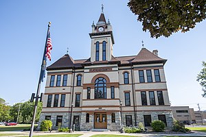
 Flathead County Courthouse in Kalispell | |
 Location within the U.S. state of Montana | |
 Montana's location within the U.S. | |
| Coordinates: 48°17′N 114°01′W / 48.29°N 114.02°W | |
| Country | |
| State | |
| Founded | 1893 |
| Named for | Flathead Indians |
| Seat | Kalispell |
| Largest city | Kalispell |
| Area | |
• Total | 5,256 sq mi (13,610 km2) |
| • Land | 5,088 sq mi (13,180 km2) |
| • Water | 169 sq mi (440 km2) 3.2% |
| Population (2020) | |
• Total | 104,357 |
• Estimate (2022) | 111,814 |
| • Density | 20/sq mi (7.7/km2) |
| Time zone | UTC−7 (Mountain) |
| • Summer (DST) | UTC−6 (MDT) |
| Congressional district | 1st |
| Website | flathead |
| |
Flathead County is a county located in the U.S. state of Montana. At the 2020 census, its population was 104,357,[1] making it the state's fourth most populous county. Its county seat is Kalispell.[2] Its numerical designation (used in the issuance of license plates) is 7. Its northern border is on the state's north border, making it contiguous with the Canada–US border, facing British Columbia.
Flathead County comprises the Kalispell, Montana Micropolitan Statistical Area, with neighboring Lake County following soon after.
- ^ "State & County QuickFacts". United States Census Bureau. Retrieved April 5, 2023.
- ^ "Find a County". National Association of Counties. Archived from the original on May 31, 2011. Retrieved June 7, 2011.
