Back Fort Denison CEB Fort Denison French Fort Denison Italian 데니슨 성채 Korean Fort Denison Swedish فورٹ ڈینسن Urdu
| Fort Denison | |
|---|---|
Mattewanye (Dharuk) | |
 Fort Denison pre-1885. (Image: National Archives of Australia) | |
 | |
| Former names | Pinchgut |
| Etymology | Sir William Thomas Denison |
| General information | |
| Status | Built as a fortress. Decommissioned circa 1930s. Now used as a national park; reserve; tourist facility; function space |
| Type | Military fortress; gunnery |
| Architectural style | Colonial fortification, castellated style |
| Location | Sydney Harbour |
| Address | North of Woolloomooloo |
| Construction started | 1841 |
| Completed | 14 November 1857 |
| Closed | circa 1930s |
| Height | |
| Observatory | Martello tower |
| Technical details | |
| Material | Sydney sandstone |
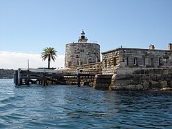
 Fort Denison with its Martello tower | |
| Location | Port Jackson, Sydney Harbour National Park |
| Nearest city | Sydney |
| Coordinates | 33°51′18″S 151°13′32″E / 33.8549°S 151.2255°E |
| Operator | NSW National Parks & Wildlife Service |
| fortdenison | |
| Official name | Fort Denison; Pinchgut; Mattewanye (Eora name) |
| Type | State heritage (built) |
| Designated | 2 April 1999 |
| Reference no. | 985 |
| Type | Fortification |
| Category | Defence |
| Builders | William Randle |
| Official name | Fort Denison, Sydney, NSW, Australia |
| Designated | 21 March 1978 |
| Reference no. | 1856 |
| References | |
| [1] | |
Fort Denison, part of the Sydney Harbour National Park, is a protected national park that is a heritage-listed former penal site and defensive facility occupying a small island located north-east of the Royal Botanic Garden and approximately 1 kilometre (0.62 mi) east of the Opera House in Sydney Harbour, New South Wales, Australia. The island is also known as Mattewanye or Muddawahnyuh in the Eora language, and as Pinchgut Island.
The site contains time gun, navigational aids and tide gauge facilities. Correctional and military facilities were designed by George Barney and built from 1840 to 1862 by William Randle. The property is owned by the Office of Environment & Heritage, an agency of the Government of New South Wales. It was added to the New South Wales State Heritage Register on 2 April 1999.[2] In 1978 the former fortress was listed on the (now defunct) Register of the National Estate,[1] and is currently used as a national park, nature reserve, tourist facility, and as a function space.
- ^ a b "Fort Denison (Place ID 1856)". Australian Heritage Database. Australian Government. 21 March 1978. Retrieved 18 June 2016.
- ^ "Fort Denison". New South Wales State Heritage Register. Department of Planning & Environment. H00985. Retrieved 2 June 2018.
 Text is licensed by State of New South Wales (Department of Planning and Environment) under CC BY 4.0 licence.
