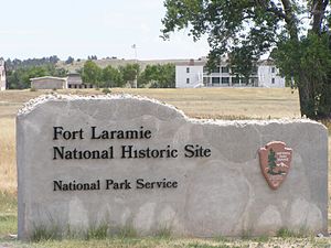
Back Fort Laramie National Historic Site CEB Fort Laramie National Historic Site Danish Fort Laramie National Historic Site Finnish Fort Laramie National Historic Site French Fort Laramie National Historic Site Dutch
| Fort Laramie National Historic Site | |
|---|---|
 | |
| Location | Goshen County, Wyoming, USA |
| Nearest city | Torrington, Wyoming |
| Coordinates | 42°12′33″N 104°32′9.1″W / 42.20917°N 104.535861°W |
| Area | 833 acres (337 ha) |
| Established | March 4, 1931 |
| Visitors | 46,455 (in 2005) |
| Governing body | National Park Service |
| Website | Fort Laramie National Historic Site |
Fort Laramie National Historic Site | |
| Nearest city | Fort Laramie, Wyoming |
| Area | 536 acres (217 ha)[2] |
| Built | 1834 |
| Built by | US Army Corps of Engineers |
| Architect | US Army Corps of Engineers |
| Architectural style | Lime grout construction |
| NRHP reference No. | 66000755[1] |
| Added to NRHP | October 15, 1966 |
Fort Laramie (/ˈlærəmi/; founded as Fort William and known for a while as Fort John) was a significant 19th-century trading post, diplomatic site, and military installation located at the confluence of the Laramie and the North Platte Rivers. They joined in the upper Platte River Valley in the eastern part of the present-day US state of Wyoming. The fort was founded as a private trading-post in the 1830s to service the overland fur trade; in 1849, it was purchased by the United States Army. The site was located east of the long climb leading to the best and lowest crossing-point over the Rocky Mountains at South Pass and became a popular stopping-point for migrants on the Oregon Trail. Along with Bent's Fort on the Arkansas River, the trading post and its supporting industries and businesses were the most significant economic hub of commerce in the region.
Fort William was founded by William Sublette and his partner Robert Campbell in 1834. In the spring of 1835, Sublette sold the fort to Thomas Fitzpatrick, a local fur trader. After a rendezvous in 1836, it was sold to the American Fur Company, which still had a virtual monopoly on the western fur trade. Starting as early as the fall of 1840, the American Fur Company began competing with the newly-established Fort Platte, built by Lancaster Lupton about a mile away from Fort William.
The American Fur Company hired workers from Santa Fe to construct an adobe fort to replace Fort William. This fort was named Fort John, after John Sarpy, a partner in the company. In 1849, the U.S. Army purchased the fort as a post to protect the many wagon trains of migrant travelers on the Oregon Trail, and the subsidiary northern emigrant trails which split off further west. These included the California and Mormon Trails. The middle reaches of the Mormon trail stayed on the north banks of the Platte and North Platte rivers, and merged with the other emigrant trails heading west over the continental divide from Fort John-Laramie. The name "Fort Laramie" gradually came into use, likely as a convenient shortening of "Fort John at the Laramie River".
The remaining structures are preserved as the Fort Laramie National Historic Site by the National Park Service.
- ^ "National Register Information System". National Register of Historic Places. National Park Service. July 9, 2010.
- ^ Tami Canaday (September 15, 1983). "National Register of Historic Places Inventory – Nomination Form: Fort Laramie National Historic Site" (PDF). National Park Service. Retrieved 2015-04-06. Two photos (1976) and 50 photos (1983)

