| Frye Fire | |
|---|---|
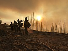
 A firefighting team near the Frye Fire, June 17, 2017 | |
| Date(s) | June 7 - September 1, 2017 |
| Location | Graham County, Arizona, US |
| Coordinates | 32°44′06″N 109°52′19″W / 32.735°N 109.872°W |
| Statistics | |
| Burned area | 48,443 acres (19,604 ha; 75.692 sq mi) |
| Impacts | |
| Damage | $26 million (equivalent to $32 million in 2023) |
| Ignition | |
| Cause | Lightning |
| Map | |
The Frye Fire was a wildfire that burned 48,443 acres (19,604 ha) in Graham County, Arizona, United States, from June 7 to September 1, 2017. The fire was ignited by a lightning strike on Mount Graham, within the Coronado National Forest, and spread rapidly until it was mostly contained on July 12. The Frye Fire destroyed three buildings, briefly threatened the Mount Graham International Observatory, cost $26 million to contain (equivalent to $32 million in 2023) and suppress, and involved more than 800 firefighters. There were no fatalities, but 63 firefighters were quarantined as a result of a strep throat outbreak.
Beginning in July 2017, rains from the annual North American monsoon season washed sediments off mountain slopes in the Frye Fire's burn scar. This runoff, consisting of rainwater, ash, and debris, clogged creeks and damaged infrastructure within Graham County. The fire particularly affected the endangered Mount Graham red squirrel, whose remaining habitat on Mount Graham was devastated.


