Back Gander Int. Airport CEB Gander International Airport German Aeropuerto Internacional de Gander Spanish فرودگاه بینالمللی گندر Persian Ganderin kansainvälinen lentoasema Finnish Aéroport international de Gander French Aeroporto de Gander Galician Gander nemzetközi repülőtér Hungarian Bandar Udara Internasional Gander ID Aeroporto Internazionale di Gander Italian
Gander International Airport | |||||||||||||||||||
|---|---|---|---|---|---|---|---|---|---|---|---|---|---|---|---|---|---|---|---|
 | |||||||||||||||||||
| Summary | |||||||||||||||||||
| Airport type | Public | ||||||||||||||||||
| Owner | Transport Canada[1] | ||||||||||||||||||
| Operator | Gander International Airport Authority | ||||||||||||||||||
| Serves | Gander, Newfoundland and Labrador | ||||||||||||||||||
| Time zone | NST (UTC−03:30) | ||||||||||||||||||
| • Summer (DST) | NDT (UTC−02:30) | ||||||||||||||||||
| Elevation AMSL | 496 ft / 151 m | ||||||||||||||||||
| Coordinates | 48°56′51″N 54°33′36″W / 48.94750°N 54.56000°W | ||||||||||||||||||
| Website | www | ||||||||||||||||||
| Maps | |||||||||||||||||||
 Transport Canada airport diagram | |||||||||||||||||||
Location in Newfoundland and Labrador | |||||||||||||||||||
 | |||||||||||||||||||
| Runways | |||||||||||||||||||
| |||||||||||||||||||
| Statistics (2022) | |||||||||||||||||||
| |||||||||||||||||||
Sources: Canada Flight Supplement[2] Environment Canada[3] Movements from Statistics Canada[4] Passengers from Gander Airport[5] | |||||||||||||||||||
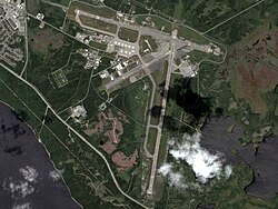
Gander International Airport (IATA: YQX, ICAO: CYQX) is located in Gander, Newfoundland and Labrador, Canada, and is operated by the Gander International Airport Authority. Canadian Forces Base Gander shares the airfield but is a separate entity from the airport. The airport is sometimes referred to as the "Crossroads of the World",[6] and is classified as an international airport by Transport Canada.[7]
- ^ "Airport Divestiture Status Report". Archived from the original on March 3, 2016. Retrieved March 30, 2007.
- ^ Canada Flight Supplement. Effective 0901Z 16 July 2020 to 0901Z 10 September 2020.
- ^ "Synoptic/Metstat Station Information". Archived from the original on December 1, 2011.
- ^ "Aircraft movements, by class of operation, airports with NAV CANADA services and other selected airports, monthly". Statistics Canada. December 21, 2022. Retrieved March 3, 2024.
- ^ "GIAA 2022 Annual Report" (PDF). ganderairport.com. Retrieved March 3, 2024.
- ^ "Stepping inside an artifact: A visit to Gander International Airport | The Channel". ingeniumcanada.org.
- ^ Advisory Circular (AC) No. 302-032 Subject: Designation of international airports in Canada
