Back Garonne Afrikaans ጋሮን ወንዝ Amharic Río Garona AN نهر غارون Arabic نهر جارون ARZ Qaronna çayı Azerbaijani قارون چایی AZB Гарона Byelorussian Гарона BE-X-OLD Гарона Bulgarian
You can help expand this article with text translated from the corresponding article in French. (July 2014) Click [show] for important translation instructions.
|
| Garonne | |
|---|---|
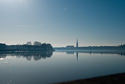
 The Garonne at Bordeaux | |
 Map of the Garonne River watershed | |
| Native name | Garona (Occitan) |
| Location | |
| Countries | France and Spain |
| Cities | |
| Physical characteristics | |
| Source | Pyrenees |
| • location | Alt Àneu, Catalonia, Spain |
| • coordinates | 42°36′26″N 0°57′56″E / 42.607295°N 0.965424°E |
| • elevation | 2,600 m (8,500 ft) |
| Mouth | Gironde estuary, Atlantic Ocean |
• location | Bayon-sur-Gironde, Nouvelle-Aquitaine, France |
• coordinates | 45°2′29″N 0°36′24″W / 45.04139°N 0.60667°W |
• elevation | 0 m (0 ft) |
| Length | 529 km (329 mi) |
| Basin size | 56,000 km2 (22,000 sq mi), or including Dordogne: 84,811 km2 (32,746 sq mi) |
| Discharge | |
| • average | 650 m3/s (23,000 cu ft/s) |
| Basin features | |
| Progression | Gironde estuary→ Atlantic Ocean |
 | |
The Garonne (/ɡəˈrɒn, ɡæˈrɒn/ gə-RON, garr-ON, French: [ɡaʁɔn] ⓘ; Catalan, Basque and Occitan: Garona, Occitan pronunciation: [ɡaˈɾunɔ]; Latin: Garumna[1][2] or Garunna) is a river that flows in southwest France and northern Spain. It flows from the central Spanish Pyrenees to the Gironde estuary at the French port of Bordeaux – a length of 529 km (329 mi),[3] of which 47 km (29 mi) is in Spain (Val d'Aran);[4] the total length extends to 602 km (374 mi) if one includes the Gironde estuary between the river and the sea. Its basin area is 56,000 km2 (22,000 sq mi),[4] which increases to 84,811 km2 (32,746 sq mi) if the Dordogne River, which flows from the east and joins the Garonne at Bec d'Ambès to form the Gironde estuary, is included.
Umayyad and Aquitanian forces fought the Battle of the River Garonne in 732 beside the river near present-day Bordeaux.
- ^ Smith, William (1850). A new classical dictionary of Greek and Roman biography, mythology, and geography. London: John Murray. p. 492. OCLC 223027795.
- ^
Smith, William (1862). "GARUMNA". In Anthon, Charles (ed.). A New Classical Dictionary of Greek and Roman Biography, Mythology and Geography, partly based upon the Dictionary of Greek and Roman Biography and Mythology by William Smith [...]. Revised by Charles Anthon (revised ed.). New York: Harper (published 1895). p. 322. Retrieved 14 December 2019.
GARUMNA (now Garonne), one of the chief rivers of Gaul, rises in the Pyrenees, flows northwest through Aquitania, and becomes a bay of the sea below Burdigala (now Bordeaux).
- ^ Sandre. "Fiche cours d'eau - La Garonne (O---0000)".
- ^ a b Le bassin versant de la Garonne, Syndicat Mixte d'Études & d'Aménagement de la Garonne