Back Xeografía d'Estonia AST Estoniya coğrafiyası Azerbaijani Эстония географияһы Bashkir Геаграфія Эстоніі Byelorussian Геаграфія Эстоніі BE-X-OLD География на Естония Bulgarian এস্তোনিয়ার ভূগোল Bengali/Bangla Geografija Estonije BS Estlands geografi Danish Γεωγραφία της Εσθονίας Greek
 | |
| Continent | Europe |
|---|---|
| Region | Northern Europe |
| Coordinates | 59°00′N 26°00′E / 59.000°N 26.000°E |
| Area | |
| • Total | 45,339 km2 (17,505 sq mi) |
| • Land | 95.4% |
| • Water | 4.6% |
| Coastline | 3,794 km (2,357 mi) |
| Borders | Total land borders: 657 km (408 mi) |
| Highest point | Suur Munamägi 317 m (1,040 ft) |
| Lowest point | Baltic Sea 0 meters |
| Longest river | Võhandu 162 km (101 mi) |
| Largest lake | Lake Peipus 3,555 km2 (1,373 sq mi) |
| Exclusive economic zone | 36,992 km2 (14,283 sq mi) |
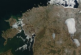
Between 57.3 and 59.5 latitude and 21.5 and 28.1 longitude, Estonia lies on the eastern coast of the Baltic Sea on the level northwestern part of the rising East European Platform. Estonia's continental mainland is bordered to the north by the Gulf of Finland (part of the Baltic Sea) across from Finland, to the east by Lake Peipus and Russia, and to the south by Latvia. Besides the part of the European continent, Estonian territory also includes the larger islands of Saaremaa and Hiiumaa, and over 2,200 other islands and islets in the Baltic Sea, off the western and northern shores of the country's mainland.
Average elevation in Estonia reaches 50 m (164 ft).
The climate is maritime, wet, with moderate winters and cool summers. Oil shale and limestone deposits, along with forests which cover 47% of the land, play key economic roles in this generally resource-poor country. Estonia boasts over 1,500 lakes, numerous bogs, and 3,794 kilometers of coastline marked by numerous bays, straits, and inlets.