Back Gitagum BCL Gitagum CBK-ZAM Gitagum CEB Gitagum German Gitágum Spanish Gitagum French Gitagum ID Gitagum ILO Gitagum Italian გიტაგუმი Georgian
Gitagum | |
|---|---|
| Municipality of Gitagum | |
 Public Market | |
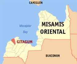
 Map of Misamis Oriental with Gitagum highlighted | |
Location within the Philippines | |
| Coordinates: 8°35′44″N 124°24′19″E / 8.595639°N 124.405414°E | |
| Country | Philippines |
| Region | Northern Mindanao |
| Province | Misamis Oriental |
| District | 2nd district |
| Founded | June 8, 1961 |
| Barangays | 11 (see Barangays) |
| Government | |
| • Type | Sangguniang Bayan |
| • Mayor | Emmanuel S. Mugot |
| • Vice Mayor | Rudy O. Damasing |
| • Representative | Yevgeny Vincente B. Emano |
| • Municipal Council | Members |
| • Electorate | 14,881 voters (2022) |
| Area | |
• Total | 43.40 km2 (16.76 sq mi) |
| Elevation | 47 m (154 ft) |
| Highest elevation | 247 m (810 ft) |
| Lowest elevation | 0 m (0 ft) |
| Population (2020 census)[3] | |
• Total | 17,920 |
| • Density | 410/km2 (1,100/sq mi) |
| • Households | 4,556 |
| Economy | |
| • Income class | 5th municipal income class |
| • Poverty incidence | 29.65 |
| • Revenue | ₱ 81.88 million (2020) |
| • Assets | ₱ 191 million (2020) |
| • Expenditure | ₱ 74.57 million (2020) |
| • Liabilities | ₱ 32.3 million (2020) |
| Service provider | |
| • Electricity | Misamis Oriental 1 Rural Electric Cooperative (MORESCO 1) |
| Time zone | UTC+8 (PST) |
| ZIP code | 9020 |
| PSGC | |
| IDD : area code | +63 (0)88 |
| Native languages | Cebuano Binukid Subanon Tagalog |
| Website | http://gitagummisor.gov.ph/ |
Gitagum, officially the Municipality of Gitagum (Cebuano: Lungsod sa Gitagum; Tagalog: Bayan ng Gitagum), is a municipality in the province of Misamis Oriental, Philippines. The municipality is bounded on the north by Mindanao Sea, on the east by the Municipality of Laguindingan, on the south by the Municipality of Alubijid and on the west the Municipality of Libertad. It is approximately 40 km. away from Cagayan de Oro.[5] According to the 2020 census, it has a population of 17,920 people.[3]
The municipality of Gitagum stretches along the shoreline of Mindanao Sea having an approximate length of 6.2 km. It has a total land area of 4,340 hectares or 43.40 square kilometers which is only 1.18% of the total land area of the province of Misamis Oriental. There are eleven barangays of which four are urban areas due to their strategic location along the national highway and along the Iligan Bay. Light commercial and industrial establishments are found in these barangays. Built up areas for urban uses comprise only 2. 5% of the total land area of Gitagum, which is utilized for residential uses and within the vicinity of the public market, business establishment, churches, school, municipal gymnasium, plaza and other government building of the municipality. The coastal barangays of Burnay and Pangayawan are vegetated with mangrove which remains protected.
The barangays along the coast are traversed by the national highway, while the interior barangays are accessible by the provincial and barangays roads which serve as farm to market roads.
- ^ Municipality of Gitagum | (DILG)
- ^ "2015 Census of Population, Report No. 3 – Population, Land Area, and Population Density" (PDF). Philippine Statistics Authority. Quezon City, Philippines. August 2016. ISSN 0117-1453. Archived (PDF) from the original on May 25, 2021. Retrieved July 16, 2021.
- ^ a b Census of Population (2020). "Region X (Northern Mindanao)". Total Population by Province, City, Municipality and Barangay. Philippine Statistics Authority. Retrieved 8 July 2021.
- ^ "PSA Releases the 2021 City and Municipal Level Poverty Estimates". Philippine Statistics Authority. 2 April 2024. Retrieved 28 April 2024.
- ^ "History and Profile | Local Government Unit of Gitagum". Retrieved 2022-04-20.


