Back الحوض الارتوازي الكبير Arabic Вялікі Артэзіянскі басейн Byelorussian Голям артезиански басейн Bulgarian Gran Conca Artesiana Catalan Great Artesian Basin CEB Velká artéská pánev Czech Großes Artesisches Becken German Gran Cuenca Artesiana Spanish Artesiar Arro Handia Basque حوضه آرتزین بزرگ Persian
Great Artesian Basin | |
|---|---|
 | |
 | |
| Location | Australia |
| Area | |
| • Total | 1,700,000 km2 (660,000 sq mi) |


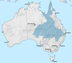
The Great Artesian Basin (GAB)[1] of Australia is the largest and deepest artesian basin in the world, extending over 1,700,000 square kilometres (660,000 sq mi). Measured water temperatures range from 30 to 100 °C (86 to 212 °F). The basin provides the only source of fresh water through much of inland Australia.[2]
The basin underlies 22% of the Australian continent,[3] including most of Queensland, the south-east corner of the Northern Territory, north-eastern South Australia, and northern New South Wales. It is 3000 metres (9800 feet) deep in places and is estimated to contain 64,900 cubic kilometres (15,600 cubic miles) of groundwater.[4] The Great Artesian Basin Coordinating Committee (GABCC)[5] coordinates activity between federal, state/territory and local levels of government and community organisations.
- ^ "Great Artesian Basin". Water. Geoscience Australia. 15 May 2014. Retrieved 19 March 2017.
- ^ Spanevello, M. D. (November 2001). The phylogeny of prokaryotes associated with Australia's Great Artesian Basin (PDF) (PhD). Griffith University. Archived from the original (PDF) on 24 September 2014. Retrieved 20 September 2014.
- ^ "Great Artesian Basin - Department of Agriculture".
- ^ Cite error: The named reference
fswas invoked but never defined (see the help page). - ^ GABCC website Archived 7 February 2007 at the Wayback Machine