Back Velké Toronto Czech Greater Toronto Area German Ευρύτερη Περιοχή του Τορόντο Greek Granda Toronto Esperanto Área metropolitana de Toronto Spanish کلانشهر تورنتو Persian Suur-Toronto Finnish Grand Toronto French טורונטו רבתי HE Wilayah Toronto Raya ID
Greater Toronto Area | |
|---|---|
 Satellite image of the Greater Toronto Area from 2018 | |
 | |
| Coordinates: 43°38′33″N 79°23′14″W / 43.64250°N 79.38722°W | |
| Country | Canada |
| Province | Ontario |
| Area | |
| • Land | 7,123.64 km2 (2,750.45 sq mi) |
| Population (2021) | |
• Total | 6,711,985 |
| • Density | 942.21/km2 (2,440.3/sq mi) |
| Combined population of Halton, Peel, Toronto, York, Durham | |
| GDP | |
| • Toronto CMA | CA$430.9 billion (2020)[1] |
| Time zone | UTC−5 (EST) |
| • Summer (DST) | UTC−4 (EDT) |
| Postal code | |
| Area code(s) | 226, 249, 289, 416, 437, 519, 647, 705, 905, 365 |
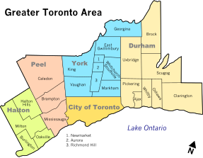
The Greater Toronto Area, commonly referred to as the GTA, includes the City of Toronto and the regional municipalities of Durham, Halton, Peel, and York. In total, the region contains 25 urban, suburban, and rural municipalities.[2][3] The Greater Toronto Area begins in Burlington in Halton Region to the west, and extends along Lake Ontario past downtown Toronto eastward to Clarington in Durham Region.
According to the 2021 census, the Census Metropolitan Area (CMA) of Toronto has a total population of 6.202 million residents, making it the nation's largest, and the 10th-largest in North America.[4] However, the Greater Toronto Area, which is an economic area defined by the Government of Ontario[citation needed], includes communities that are not included in the CMA, as defined by Statistics Canada. Extrapolating the data for all 25 communities in the Greater Toronto Area from the 2021 Census, the total population for the economic region included 6,711,985 people.[citation needed]
The Greater Toronto Area is a part of several larger areas in Southern Ontario. The area is also combined with the city of Hamilton to form a conurbation known as the Greater Toronto and Hamilton Area (GTHA).[5][6] The GTHA combined with Niagara Region form the core of the Golden Horseshoe.
- ^ "Statistics Canada. Table 36-10-0468-01 Gross domestic product (GDP) at basic prices, by census metropolitan area (CMA) (x 1,000,000)". Statistics Canada.
- ^ OECD "OECD Territorial Reviews OECD Territorial Reviews: Toronto, Canada 2009" OECD Publishing, ISBN 92-64-07940-8 p37
- ^ "Greater Toronto Area" (PDF). Ontario Creates. Retrieved February 14, 2022.
- ^ 2021 Census - Toronto Metropolitan area (Report). Ottawa: Statistics Canada. February 9, 2022. Retrieved February 10, 2022.
- ^ "Places to Grow: Growth Plan for the Greater Golden Horseshoe" (PDF). Ministry of Public Infrastructure Renewal. 2006. p. 9. Archived from the original (PDF) on July 6, 2011.
- ^ "Amendment No. 38 to the Regional Plan (2006)". Regional Municipality of Halton. December 16, 2009. Archived from the original on July 6, 2011. Retrieved March 25, 2010.

